


A San Francisco nonprofit is developing a set of recommendations for making downtown neighborhoods more flexible and welcoming to a more diverse set of users.
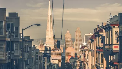
A San Francisco nonprofit is working on a plan to redesign the city's streets to address the changes wrought by the COVID-19 pandemic and find ways to adjust to the post-COVID future, reports Jason Plautz.
The city hopes to revitalize areas that have seen a decline in users as remote work and other changes alter traditional commuting patterns and affect business for restaurants, shops, and other downtown services that historically relied on office workers. Around the country, once-bustling central cities emptied out as office workers shifted to remote work and businesses shuttered. According to Robbie Silver, executive director of Downtown Community Benefit District (CBD), the organization leading this initiative, San Francisco's Financial District "is a prime example of an urban space that suffered in the pandemic."
Downtown CBD has tasked SITELAB urban studio with conducting public outreach and developing a set of recommendations for how the city can make downtown neighborhoods "more inviting and flexible" for a wider variety of users. The article quotes Laura Crescimano, co-founder and principal at SITELAB: "If you look at European downtowns and other cities with vibrant downtowns, they serve more a multi-function, multi-purpose role." Figuring out what those multiple functions are for San Francisco, says Crescimano, is one of the major questions the project seeks to answer.
FULL STORY: Initiative will rethink San Francisco downtown for 'post-COVID' work patterns

Office Landlords Luring Tenants Back With Incentives
Landlords are offering generous incentives in an effort to prop up the struggling U.S. office market.
The Return to the Office Around the World
Cities around the world are employing vastly different strategies in the effort to get workers back in the office.
Major US Cities Still Suffering Downtown Decline
Research shows that the “donut effect” hollowing out central business districts since the pandemic continues to cause economic decline in the 12 largest American cities.

Montreal Mall to Become 6,000 Housing Units
Place Versailles will be transformed into a mixed-use complex over the next 25 years.

Planetizen Federal Action Tracker
A weekly monitor of how Trump’s orders and actions are impacting planners and planning in America.

DARTSpace Platform Streamlines Dallas TOD Application Process
The Dallas transit agency hopes a shorter permitting timeline will boost transit-oriented development around rail stations.

Interactive Map Reveals America's “Shade Deserts”
Launched by UCLA and American Forests to combat heat-related deaths, the tool maps the shade infrastructure for over 360 U.S. cities.

Bicycles and Books — In Sacramento, Libraries Now Offer Both
Adult library card holders can check out e-bikes and e-trikes for up to one week.

Colorado Landfills Emit as Much Pollution as 1M Cars
Landfills are the third-largest source of methane pollution in Colorado, after agriculture and fossil fuel extraction.
Urban Design for Planners 1: Software Tools
This six-course series explores essential urban design concepts using open source software and equips planners with the tools they need to participate fully in the urban design process.
Planning for Universal Design
Learn the tools for implementing Universal Design in planning regulations.
City of Mt Shasta
City of Camden Redevelopment Agency
City of Astoria
Transportation Research & Education Center (TREC) at Portland State University
US High Speed Rail Association
City of Camden Redevelopment Agency
Municipality of Princeton (NJ)