


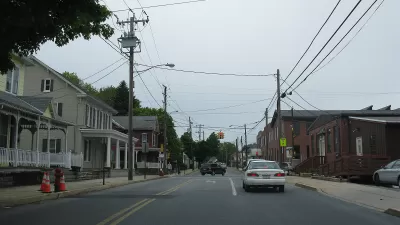
Arlington County is allowing land use flexibility on ground floors in the hopes of transforming the Columbia Park as more of a pedestrian-oriented "Main Street."
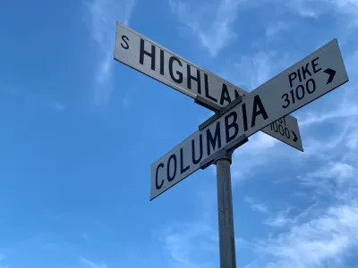
The Arlington County Board voted unanimously to allow "greater flexibility for commercial, office, light industrial, and agricultural uses—including animal boarding and craft beverage production—on ground floors along the [Columbia] Pike," according to a November 13 press release from Arlington County'.
"The changes approved at the Saturday, Nov. 13, Board meeting will enhance the variety of businesses serving the Columbia Pike community, attract new customers for area businesses, and increase opportunities for first-time and minority business owners. County staff recommended the changes based on over a year of research, analysis, and engagement with residents, property owners, and the business community," according to the press release.
According to the press release, the changes respond to market conditions along the Columbia Pike and with the planned goals of making the corridor more of a walkable "Main Street" with increased pedestrian activity.
Hat tip to Matt Gontarchik for sharing the news.
FULL STORY: Arlington Banner County Board Expands Ground Story Uses along Columbia Pike

A Small Town Makes its First Zoning Update Since 1997
Mixed-use development and a floodplain overlay are the big-ticket items when the small community of Akron Borough in Pennsylvania recently updated its zoning code.

Ranking Exclusionary Zoning: D.C., New York Metro Areas Top the List
A new database measures the restrictiveness of exclusionary zoning practices around the country. Exclusionary zoning, it turns out, is much more prevalent than commonly acknowledged.

Zoning Has Support for Sprawl: Subdivision, Covenants, and Mortgages
Zoning codes are not the only kind of land use control that has built the U.S. residential market on the suburban model for more than a century, according to a recent article in The Urbanist.

Montreal Mall to Become 6,000 Housing Units
Place Versailles will be transformed into a mixed-use complex over the next 25 years.

Planetizen Federal Action Tracker
A weekly monitor of how Trump’s orders and actions are impacting planners and planning in America.

DARTSpace Platform Streamlines Dallas TOD Application Process
The Dallas transit agency hopes a shorter permitting timeline will boost transit-oriented development around rail stations.

Without International Immigrants, the Rural US Population Would Be Falling 58%
Census data shows that population growth in rural areas is due in large part to international migrants.

Dead End: Nine Highways Ready for Retirement
The Freeways Without Futures report describes the nation’s most promising highway removal proposals.

Congressman Proposes Bill to Rename DC Metro “Trump Train”
The Make Autorail Great Again Act would withhold federal funding to the system until the Washington Metropolitan Area Transit Authority (WMATA), rebrands as the Washington Metropolitan Authority for Greater Access (WMAGA).
Urban Design for Planners 1: Software Tools
This six-course series explores essential urban design concepts using open source software and equips planners with the tools they need to participate fully in the urban design process.
Planning for Universal Design
Learn the tools for implementing Universal Design in planning regulations.
City of Mt Shasta
City of Camden Redevelopment Agency
City of Astoria
Transportation Research & Education Center (TREC) at Portland State University
City of Camden Redevelopment Agency
Municipality of Princeton (NJ)
Regional Transportation Commission of Southern Nevada