


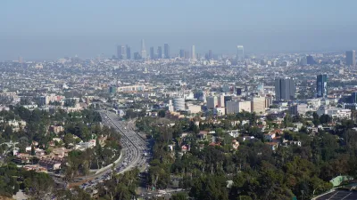
Google has unveiled a new tool called Tree Canopy Lab in an effort to keep cities like Los Angeles cool by helping them to know where to plant more trees.

Many of us would probably agree that planting more trees is a good thing. Cities tend to be warmer than surrounding areas because buildings and asphalt trap heat, resulting in the urban heat island effect. One way to cool urban areas down is to plant more trees in neighborhoods where they are sparse.
The challenge is knowing where to plant trees strategically to benefit those who need them most. As Justine Calma explains in this article, Google has released a tool that can help. Specifically, Google's new Tree Canopy Lab can help cities keep their residents cool by mapping out where trees are needed most.
Tree Canopy Lab uses aerial imagery and Google’s artificial intelligence to figure out where every tree is in a city. The tool then puts that information on an interactive map along with additional data layers on which neighborhoods are more densely populated and are more vulnerable to high temperatures. The idea is that planting new trees in these areas can help cities adapt to a warming world and save lives during heat waves.
Google piloted Tree Canopy Lab in Los Angeles. Data on hundreds more cities is on the way. Tree Canopy Lab found that over half of L.A. residents live in places where trees shade less than 10 percent of their neighborhood. It also found that 44 percent of Angelenos live in places with extreme heat risk. Heat waves in Los Angeles County have gotten longer, more frequent, and more intense over the past 50 years.
FULL STORY: Google launches new tool to help cities stay cool

Updating LA’s Tree Rules Could Bring More Shade to Underserved Neighborhoods
A new USC study finds that relaxing Los Angeles’ outdated tree planting guidelines could significantly expand urban tree canopy and reduce shade disparities in lower-income neighborhoods, though infrastructure investments are also needed.

Improving South Los Angeles Through Strategic Tree Planting
The University of Southern California Urban Trees Initiative is planting 250 trees in South L.A. neighborhoods to improve shade, combat climate change, and enhance community well-being through collaboration and data-driven approaches.
Invasive Beetles Put Oregon Forests at Risk
Two recently discovered borer beetles could lead to a significant loss of tree canopy.

Planetizen Federal Action Tracker
A weekly monitor of how Trump’s orders and actions are impacting planners and planning in America.

Congressman Proposes Bill to Rename DC Metro “Trump Train”
The Make Autorail Great Again Act would withhold federal funding to the system until the Washington Metropolitan Area Transit Authority (WMATA), rebrands as the Washington Metropolitan Authority for Greater Access (WMAGA).

The Simple Legislative Tool Transforming Vacant Downtowns
In California, Michigan and Georgia, an easy win is bringing dollars — and delight — back to city centers.

The States Losing Rural Delivery Rooms at an Alarming Pace
In some states, as few as 9% of rural hospitals still deliver babies. As a result, rising pre-term births, no adequate pre-term care and "harrowing" close calls are a growing reality.

The Small South Asian Republic Going all in on EVs
Thanks to one simple policy change less than five years ago, 65% of new cars in this Himalayan country are now electric.

DC Backpedals on Bike Lane Protection, Swaps Barriers for Paint
Citing aesthetic concerns, the city is removing the concrete barriers and flexposts that once separated Arizona Avenue cyclists from motor vehicles.
Urban Design for Planners 1: Software Tools
This six-course series explores essential urban design concepts using open source software and equips planners with the tools they need to participate fully in the urban design process.
Planning for Universal Design
Learn the tools for implementing Universal Design in planning regulations.
Smith Gee Studio
City of Charlotte
City of Camden Redevelopment Agency
City of Astoria
Transportation Research & Education Center (TREC) at Portland State University
US High Speed Rail Association
City of Camden Redevelopment Agency
Municipality of Princeton (NJ)