


The massive Port Lands infrastructure project will transform an industrial area by carving out a new island.
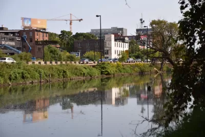
Kenyon Wallace takes a closer look at the Port Lands Flood Protection Project, a $1.25 billion project to naturalize the Don River pathway and help with flood control through construction of a river valley that will result in an island at the river’s mouth.
"The Port Lands, located south of Lake Shore Boulevard between Leslie Street in the east and Cherry Street in the west, are a primarily industrial and commercial neighbourhood built on landfill that was once home to oil tank farms, factories and a city incinerator," writes Wallace.
He describes the different phases of the project in more detail, including the excavation of the river valley, treatment of groundwater, and landscaping along the edge of the river. The entire area will also be raised and will undergo soil stabilization.
"The new island, named Villiers Island, will feature parklands, walking and biking trails, and residential and commercial real estate (not to mention great views of the city skyline). It will also feature the only natural shoreline within the inner harbour, allowing for easy entry into Lake Ontario with canoes and kayaks," says Wallace.
FULL STORY: How do you build an island in Toronto?

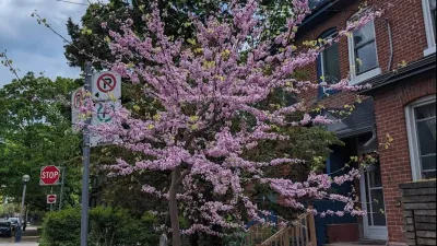
The Most Popular Tree on Google?
Meet Rodney: the Toronto tree getting rave reviews.

Expanding the Concept of Transit-Oriented Development: Lessons from Abroad
Keeping transit planning and development siloed can limit opportunities to build affordable housing and vibrant neighborhoods.

3D Modeling Aids in Predicting Hurricane Damage
Texas researchers are testing the tool in Galveston, where Hurricane Ike caused billions in damage in 2008.

Planetizen Federal Action Tracker
A weekly monitor of how Trump’s orders and actions are impacting planners and planning in America.

Congressman Proposes Bill to Rename DC Metro “Trump Train”
The Make Autorail Great Again Act would withhold federal funding to the system until the Washington Metropolitan Area Transit Authority (WMATA), rebrands as the Washington Metropolitan Authority for Greater Access (WMAGA).

The Simple Legislative Tool Transforming Vacant Downtowns
In California, Michigan and Georgia, an easy win is bringing dollars — and delight — back to city centers.

The States Losing Rural Delivery Rooms at an Alarming Pace
In some states, as few as 9% of rural hospitals still deliver babies. As a result, rising pre-term births, no adequate pre-term care and "harrowing" close calls are a growing reality.

The Small South Asian Republic Going all in on EVs
Thanks to one simple policy change less than five years ago, 65% of new cars in this Himalayan country are now electric.

DC Backpedals on Bike Lane Protection, Swaps Barriers for Paint
Citing aesthetic concerns, the city is removing the concrete barriers and flexposts that once separated Arizona Avenue cyclists from motor vehicles.
Urban Design for Planners 1: Software Tools
This six-course series explores essential urban design concepts using open source software and equips planners with the tools they need to participate fully in the urban design process.
Planning for Universal Design
Learn the tools for implementing Universal Design in planning regulations.
Smith Gee Studio
City of Charlotte
City of Camden Redevelopment Agency
City of Astoria
Transportation Research & Education Center (TREC) at Portland State University
US High Speed Rail Association
City of Camden Redevelopment Agency
Municipality of Princeton (NJ)