


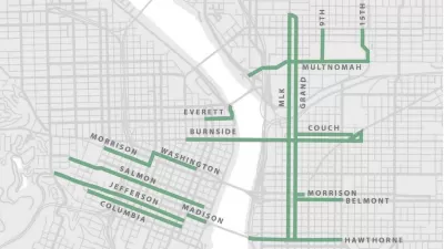
It's a draft map, but it's a big, bold draft map.
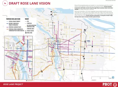
"Portland transportation officials released more information this week on its proposal to speed up bus and streetcar lines through congested streets across the city," reports Andrew Theen.
The new details of the Rose Lane Vision project include a map. To plot this draft map, the city "focused its proposals on routes that already are significantly delayed, carry more than 1,500 riders every day, and operate with at least four buses an hour in a single direction," according to Theen.
For faster and more reliable service on buses and streetcars, the city is considering a variety of methods, including dedicated bus lanes, bus lanes that allow right-turning vehicles, signal priority, queue jumps, and share bus-bike lanes.
FULL STORY: Draft Rose Lane Vision

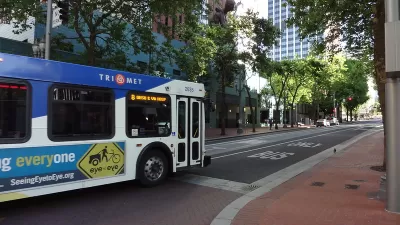
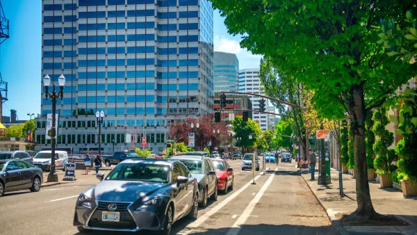
'Rose Lane Project' Proposed to Prioritize Bus Improvements in Portland
The city of Portland last week revealed a new transit planning project intended to speed up and increase bus service, and hopefully increase ridership as a result.
Federal Approval Clears Way for Bus-Only Lanes in Portland
Portland will soon be spreading out the red carpet for buses.
Portland Raises Parking Fees to Pay for Street Maintenance
The city is struggling to bridge a massive budget gap at the Bureau of Transportation, which largely depleted its reserves during the Civd-19 pandemic.

Maui's Vacation Rental Debate Turns Ugly
Verbal attacks, misinformation campaigns and fistfights plague a high-stakes debate to convert thousands of vacation rentals into long-term housing.

Planetizen Federal Action Tracker
A weekly monitor of how Trump’s orders and actions are impacting planners and planning in America.

In Urban Planning, AI Prompting Could be the New Design Thinking
Creativity has long been key to great urban design. What if we see AI as our new creative partner?

Massachusetts Budget Helps Close MBTA Budget Gap
The budget signed by Gov. Maura Healey includes $470 million in MBTA funding for the next fiscal year.

Milwaukee Launches Vision Zero Plan
Seven years after the city signed its Complete Streets Policy, the city is doubling down on its efforts to eliminate traffic deaths.

Portland Raises Parking Fees to Pay for Street Maintenance
The city is struggling to bridge a massive budget gap at the Bureau of Transportation, which largely depleted its reserves during the Civd-19 pandemic.
Urban Design for Planners 1: Software Tools
This six-course series explores essential urban design concepts using open source software and equips planners with the tools they need to participate fully in the urban design process.
Planning for Universal Design
Learn the tools for implementing Universal Design in planning regulations.
Gallatin County Department of Planning & Community Development
Heyer Gruel & Associates PA
JM Goldson LLC
City of Camden Redevelopment Agency
City of Astoria
Transportation Research & Education Center (TREC) at Portland State University
Jefferson Parish Government
Camden Redevelopment Agency
City of Claremont