


Low density sprawl stretches the tax dollars of every resident. That fact could be used to support plans for more infill density, according to this article set in the city of Winnipeg, Manitoba.
"Planners at the City of Winnipeg are currently in the process of writing a residential infill strategy to guide new development in the city’s older neighbourhoods," according to a column by Brent Bellamy, creative director at Number Ten Architectural Group in Winnipeg.
The column makes one argument for why infill development would be a good thing for the city: sprawl costs too much.
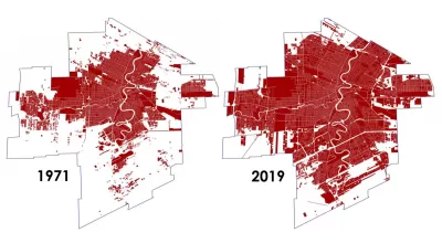
A "jaw-dropping graphic" recently released by the city, compares the built-up area of Winnipeg in the 1970s to the Winnipeg of today. "In that time, the footprint of the city increased by 96 per cent, almost doubling, while the population increased by only 37 per cent. The conclusion was that the city is currently growing three times faster in area than it is in population," explains Bellamy.
That sprawl has economic repercussions, Bellamy writes: "Compared to 45 years ago, each individual Winnipegger is today responsible for the cost of maintaining almost 50 per cent more land area, and its corresponding services and infrastructure." Tax dollars stretched so far contributes to facts of life like potholes, rising taxes, and declining public service, according to Bellamy.
FULL STORY: City's expanding footprint has high cost

To Build More Housing, Cities Must Be Smarter in How They Use Land
How strategic land use policy decisions can alleviate the housing crisis and limit unsustainable sprawl.

Promoting Infill Development for a Denser Houston
An advocacy group is calling for ‘sustainable, vertical’ mixed-use urbanism in the famously sprawling city.
Examining Oregon’s Unique Land Use Laws
Since the 1970s, the state has taken a comprehensive approach to development, regulating land use and urban growth at the state level.

Montreal Mall to Become 6,000 Housing Units
Place Versailles will be transformed into a mixed-use complex over the next 25 years.

Planetizen Federal Action Tracker
A weekly monitor of how Trump’s orders and actions are impacting planners and planning in America.

DARTSpace Platform Streamlines Dallas TOD Application Process
The Dallas transit agency hopes a shorter permitting timeline will boost transit-oriented development around rail stations.

Interactive Map Reveals America's “Shade Deserts”
Launched by UCLA and American Forests to combat heat-related deaths, the tool maps the shade infrastructure for over 360 U.S. cities.

Bicycles and Books — In Sacramento, Libraries Now Offer Both
Adult library card holders can check out e-bikes and e-trikes for up to one week.

Colorado Landfills Emit as Much Pollution as 1M Cars
Landfills are the third-largest source of methane pollution in Colorado, after agriculture and fossil fuel extraction.
Urban Design for Planners 1: Software Tools
This six-course series explores essential urban design concepts using open source software and equips planners with the tools they need to participate fully in the urban design process.
Planning for Universal Design
Learn the tools for implementing Universal Design in planning regulations.
City of Mt Shasta
City of Camden Redevelopment Agency
City of Astoria
Transportation Research & Education Center (TREC) at Portland State University
US High Speed Rail Association
City of Camden Redevelopment Agency
Municipality of Princeton (NJ)