


The Port of San Francisco is wrapping up a three-year planning process to chart the ongoing transformation of the city's waterfront.
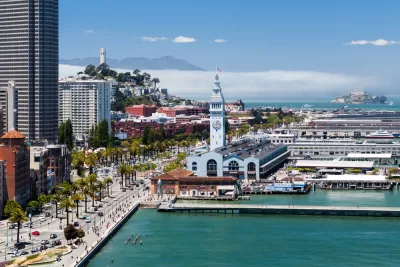
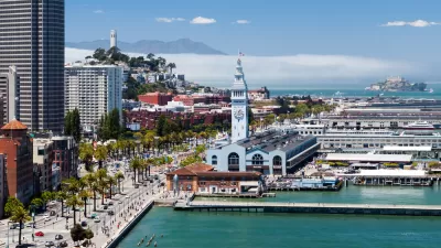
John King shares news of a plan released earlier this month that sets a path for the future of 7.5 miles of waterfront property owned by the port of San Francisco, stretching from Fisherman’s Wharf to Heron’s Head Park in the Bayview. "Along the way are such popular destinations as the Ferry Building and the Giants’ ballpark along the Embarcadero, but also the dormant ship repair dry dock at Pier 70 and a large recycling plant at Pier 96," explains King of the significance of this part of town.
The new plan follows on previous plan, written over two decades ago, that set in motion the revival of large portions of the waterfront. "But stubborn challenges remain," according to King, like a steady stream of development controversies and the need to prepare for sea-level rise. In response to the controversies, the plan sets goals of "Partnering for Success" and involving the community in decisions and whatever new amenities emerge from the plan.
Among the other specific recommendations of the report, citied by King in the article:
- Converting the paved area behind the Ferry Building into a "true piazza."
- Offering piers 3-32 to private development.
- Reopening the ship repair facilities at Pier 70 to attract high-paying jobs to the area.
King, who provides a lot more detail on the new plan in the source article, reported extensively on the outcomes of the previous plan in 2014 when the Port of San Francisco was ramping up to begin the process that produced the new plan.
FULL STORY: Plan unveiled for San Francisco’s waterfront — includes Ferry Building ‘piazza’

San Francisco Plans for 82,000 New Housing Units
California housing regulators have granted preliminary approval for the city of San Francisco’s housing element as mandated by the state’s Regional Housing Needs Allocation process.
San Francisco Returns $15 Million Federal Grant for Market Street Improvements
San Francisco was awarded a federal grant in 2018 that it was forced to return in 2022 because it couldn't start construction by 2025.
Port of San Francisco, Army Corps of Engineers Planning for Rising Bay Waters
A massive climate adaptation planning effort is underway for the docks (and seawalls and landfill) of the San Francisco Bay.

Planetizen Federal Action Tracker
A weekly monitor of how Trump’s orders and actions are impacting planners and planning in America.

Congressman Proposes Bill to Rename DC Metro “Trump Train”
The Make Autorail Great Again Act would withhold federal funding to the system until the Washington Metropolitan Area Transit Authority (WMATA), rebrands as the Washington Metropolitan Authority for Greater Access (WMAGA).

DARTSpace Platform Streamlines Dallas TOD Application Process
The Dallas transit agency hopes a shorter permitting timeline will boost transit-oriented development around rail stations.

Renters Now Outnumber Homeowners in Over 200 US Suburbs
High housing costs in city centers and the new-found flexibility offered by remote work are pushing more renters to suburban areas.

The Tiny, Adorable $7,000 Car Turning Japan Onto EVs
The single seat Mibot charges from a regular plug as quickly as an iPad, and is about half the price of an average EV.

Supreme Court Ruling in Pipeline Case Guts Federal Environmental Law
The decision limits the scope of a federal law that mandates extensive environmental impact reviews of energy, infrastructure, and transportation projects.
Urban Design for Planners 1: Software Tools
This six-course series explores essential urban design concepts using open source software and equips planners with the tools they need to participate fully in the urban design process.
Planning for Universal Design
Learn the tools for implementing Universal Design in planning regulations.
Municipality of Princeton
Roanoke Valley-Alleghany Regional Commission
City of Mt Shasta
City of Camden Redevelopment Agency
City of Astoria
Transportation Research & Education Center (TREC) at Portland State University
US High Speed Rail Association
City of Camden Redevelopment Agency
Municipality of Princeton (NJ)