


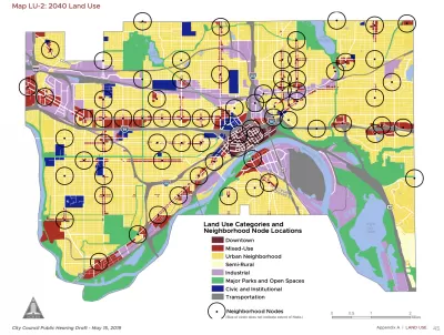
The St. Paul 2040 Comprehensive Plan aims for missing middle density at 56 "Neighborhood Nodes" around the city.
Frederick Melo reports on the details of the new 20-year comprehensive plan for St. Paul, under consideration at a series of public meetings this month and expected for a City Council by January.
According to Melo, the "St. Paul for All 2040 Comprehensive Plan" focuses growth around "Neighborhood Nodes":
St. Paul wants and needs to grow, and to do that, city planners have pinpointed 56 intersections where denser new housing, retail, transit stops and other important services could happily co-exist. That may mean lifting zoning and density restrictions, or taking advantage of zoning that already exists, to incorporate these future “neighborhood nodes” into local planning.
The entire comprehensive plan is split into six chapters, on land use, transportation, parks and open space, housing, water resources, and historic preservation, according to Melo's explanation. "The chapters touch on six themes — urban design, economic development, resiliency in the face of intense environmental changes, public health, helping residents remain in their neighborhoods as they age, and reducing racial disparities through equitable distribution of city services."
FULL STORY: St. Paul’s 20-year plan calls for more development at 56 neighborhood intersections


Charlotte's New, Controversial Comprehensive Plan to End Single-Family Zoning
A tight vote after months of controversy has produced a major zoning reform effort that differs significantly from recent examples on the West Coast and in Minneapolis.

D.C. Comprehensive Plan Amendments Approved
New amendments to the D.C. Comprehensive Plan set goals for new housing development and fewer cars on the road.

Rapid Growth and a Small Town Recall Effort
A group of organizers in the small town of Elizabeth, Colorado (population 1,700) wants to recall its entire City Council as an act of defiance in the face of rapid change and growth.

Planetizen Federal Action Tracker
A weekly monitor of how Trump’s orders and actions are impacting planners and planning in America.

San Francisco's School District Spent $105M To Build Affordable Housing for Teachers — And That's Just the Beginning
SFUSD joins a growing list of school districts using their land holdings to address housing affordability challenges faced by their own employees.

The Tiny, Adorable $7,000 Car Turning Japan Onto EVs
The single seat Mibot charges from a regular plug as quickly as an iPad, and is about half the price of an average EV.

With Protected Lanes, 460% More People Commute by Bike
For those needing more ammo, more data proving what we already knew is here.

In More Metros Than You’d Think, Suburbs are Now More Expensive Than the City
If you're moving to the burbs to save on square footage, data shows you should think again.

The States Losing Rural Delivery Rooms at an Alarming Pace
In some states, as few as 9% of rural hospitals still deliver babies. As a result, rising pre-term births, no adequate pre-term care and "harrowing" close calls are a growing reality.
Urban Design for Planners 1: Software Tools
This six-course series explores essential urban design concepts using open source software and equips planners with the tools they need to participate fully in the urban design process.
Planning for Universal Design
Learn the tools for implementing Universal Design in planning regulations.
Smith Gee Studio
City of Charlotte
City of Camden Redevelopment Agency
City of Astoria
Transportation Research & Education Center (TREC) at Portland State University
US High Speed Rail Association
City of Camden Redevelopment Agency
Municipality of Princeton (NJ)