


The environmental impact report for the North Houston Highway Improvement Project is still underway, after 15 years of planning, but it's not too early to imagine the consequences of this massive project.
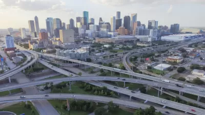
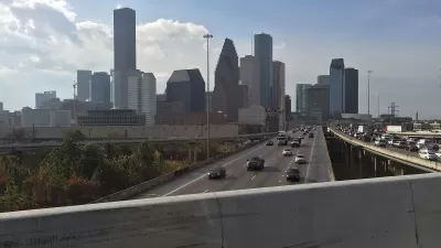
William Fulton kicks off a series on a massive highway project in Houston that will widen Interstate 45 at an estimated cost of $7 to $10 billion. "Looking beyond its sheer size, the project will shape mobility and development patterns for decades to come," writes Fulton.
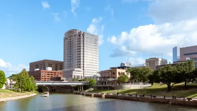
The North Houston Highway Improvement Project (NHHIP, popularly referred to as "the I-45 project," has been in the works for 15 years, with the intention "[tackling] mobility problems all the way from North Houston to Midtown, south of downtown." Fulton explains the scope of the project in more detail:
On the North Side, TxDOT will widen I-45 to accommodate high-occupancy vehicle lanes and will likely expand the frontage road on both sides.
Through Downtown, the project would re-route I-45 alongside I-69 (the former Highway 59) to the east of the George R. Brown Convention Center (GRB) and decommission, if not remove, the Pierce Elevated, thus reconnecting Downtown and Midtown. A seven-block “cap” will cover the freeway behind the GRB, creating the possibility of a park that reconnects Downtown to EaDo. South of Downtown, TxDOT will change I-69 from elevated to depressed, connecting it to the depressed I-69 freeway through Montrose and several small caps will be constructed over the freeway near Main Street. Proposed plans can be seen in the video below.
The Rice Kinder Institute for Urban Research published Fulton's article on its blog, Urban Edge, as a first in a series of articles that will give experts a chance to weight in on the implications of the project for the city of Houston.
The second article in the series was written by Bob Eury, and describes the projects as a "once-in-a-lifetime" opportunity.
FULL STORY: Experts to share what TxDOT's I-45 project means for Houston

Proposed Park Yet Another Hurdle for Houston Interstate Expansion
The Interstate 45 widening project, halted by a federal order and opposed by many local officials and organizations, could hit a new snag if White Oak Bayou becomes a city park.
A Freeway Rebellion Rises in the Unlikeliest of States: Texas
“There’s no train, there’s no bus, there’s no anything that supports mass transportation. It doesn’t exist.” -Houston resident Fabian Ramirez.
Contentious Houston Freeway Widening Project Inches Forward
Federal officials have given TxDOT the go-ahead to resume work on a small portion of a controversial interstate widening project in downtown Houston.

Planetizen Federal Action Tracker
A weekly monitor of how Trump’s orders and actions are impacting planners and planning in America.

Congressman Proposes Bill to Rename DC Metro “Trump Train”
The Make Autorail Great Again Act would withhold federal funding to the system until the Washington Metropolitan Area Transit Authority (WMATA), rebrands as the Washington Metropolitan Authority for Greater Access (WMAGA).

DARTSpace Platform Streamlines Dallas TOD Application Process
The Dallas transit agency hopes a shorter permitting timeline will boost transit-oriented development around rail stations.

Fungi to the Rescue: How Mushrooms Are Helping Clean Up Toxic Lands
Fungi are emerging as powerful tools in environmental cleanup, with scientists and community leaders using mushrooms to break down pollutants and restore contaminated soil.

DC, Columbus Bike Share Fleets Introduce Cargo Bikes
Shared mobility is ‘growing up,’ with rental options increasingly expanding to include e-bikes, scooters, and cargo bikes.

Five Key Transportation Funding Proposals in Trump’s Budget
The President’s proposed 2026 budget would keep spending roughly the same for transit and rail and eliminate over $5 billion in funding for EV charging infrastructure.
Urban Design for Planners 1: Software Tools
This six-course series explores essential urban design concepts using open source software and equips planners with the tools they need to participate fully in the urban design process.
Planning for Universal Design
Learn the tools for implementing Universal Design in planning regulations.
City of Charlotte
Municipality of Princeton
Roanoke Valley-Alleghany Regional Commission
City of Camden Redevelopment Agency
City of Astoria
Transportation Research & Education Center (TREC) at Portland State University
US High Speed Rail Association
City of Camden Redevelopment Agency
Municipality of Princeton (NJ)