


The extended tollway would cut beyond the Urban Growth Boundary into the Everglades.
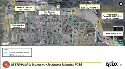
According to Jay Koziarz, "a controversial plan to extend the Dolphin Expressway through the Everglades to West Kendall was OK’d by Miami-Dade commissioners on Thursday by a 9-4 vote."
The project will add 13 miles of tollway on land located beyond the Urban Development Boundary established to protect this corner of the Everglades.
Despite the decision by Miami-Dade commissioners to approve the preliminary plan for the extended expressway, there's still a lot of ground to cover before the project is ready to break ground. Koziarz explains:
Despite winning over the majority of commissioners and appearing to be a forgone conclusion, the project still needs to secure state, federal, and Department of Environmental Resources Management permits. Meanwhile, the county’s new “sexy highway” could potentially face some not-so-sexy lawsuits. Stay tuned.
Another article written by Jenny Staletovich just before the commission's vote digs into the lack of a solid route plan for the project. "In a legal notice published in advance of the hearing last week, the county included a map depicting an eastern route. Commissioners’ application packet, however, contains a map with the route to the west," writes Staletovich. Opponents of the project seized on the lack of detail and transparency as the commission considered the plan.
FULL STORY: Miami-Dade approves Dolphin Expressway extension through the Everglades


California Environmental Leaders Call on State Agencies to Prioritize Multimodal Transportation
Even before President Trump took office, California was not meeting its emissions reduction goals.
Opinion: LA Should Reject ‘Misguided’ Car-Centric Policies
Even as the city highlights clean energy and transportation for the 2028 Olympics, Metro and Caltrans move forward with plans to expand highways.
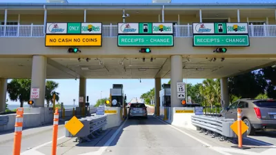
Florida to Provide Toll Relief for Frequent Commuters
It will be cheaper to drive around Florida, starting January 1.

Montreal Mall to Become 6,000 Housing Units
Place Versailles will be transformed into a mixed-use complex over the next 25 years.

Planetizen Federal Action Tracker
A weekly monitor of how Trump’s orders and actions are impacting planners and planning in America.

DARTSpace Platform Streamlines Dallas TOD Application Process
The Dallas transit agency hopes a shorter permitting timeline will boost transit-oriented development around rail stations.

Study: 4% of Truckers Lack a Valid Commercial License
Over 56% of inspected trucks had other violations.

Chicago Judge Orders Thousands of Accessible Ped Signals
Only 3% of the city's crossing signals are currently accessible to blind pedestrians.

Philadelphia Swaps Car Lanes for Bikeways in Unanimous Vote
The project will transform one of the handful of streets responsible for 80% of the city’s major crashes.
Urban Design for Planners 1: Software Tools
This six-course series explores essential urban design concepts using open source software and equips planners with the tools they need to participate fully in the urban design process.
Planning for Universal Design
Learn the tools for implementing Universal Design in planning regulations.
City of Mt Shasta
City of Camden Redevelopment Agency
City of Astoria
Transportation Research & Education Center (TREC) at Portland State University
US High Speed Rail Association
City of Camden Redevelopment Agency
Municipality of Princeton (NJ)