


A new startup wants to use blockchain and the Uber model to create free, open-source maps.
CityLab's Laura Bliss profiles a mapping startup that aims to combine blockchain and cryptocurrency, open data, and crowdsourcing and gig work. In other words, the company plans to pay people to contribute to free maps. Bliss reports:
"With $1 million in seed funding, Streetcred is building a business model based on the blockchain, where digital tokens called Ether—a Bitcoin-esque cryptocurrency with a fluctuating dollar value—would be paid out to contributors anywhere in the world to populate maps with new points of interest."
The company will only map places, not routes. It hopes to compete with the current industry king, Google Maps, by making its service free to the developers, government agencies, and companies that currently pay Google up to thousands of dollars a month. Though still "refining" its business model, Streetcred says it would make money by soliciting "sponsorships" from companies like Uber or Apple to map points of interest in regions with less coverage from other services.
It could also save money by paying contractors in an unguaranteed currency rather than hiring employees.
In CityLab, Bliss compares the startup's model to other mapping platforms, companies relying on gig workers, and data services.
FULL STORY: Like Uber, but for Cartographers


Real-Time Art Installation Reveals the Many Dimensions of Data
Using a wagon filled with phones, an artist in Berlin demonstrated the disconnect between data and the real world.
Top 10 Free Web Applications for Planning
I had the opportuntity, at the 2009 national planning conference in Minneapolis, to present (together with my colleague Christian Peralta Madera) ten free web applications that can be used to support planning. Approximately 350 participants attended the session. Since the presentation, I've received over 100 emails congratulating us on the practical nature of the presentation, and requesting links to the websites we presented. Since our presentation was a hands-on demonstration, this blog entry outlines the ten technologies, and provides links to examples of the technology in practice and resources so you can experiment with the technologies.
New App Pays Users to Report Illegally Parked Cars
A Swedish company is leveraging the power of crowdsourcing and the gig economy to enforce parking laws.

Planetizen Federal Action Tracker
A weekly monitor of how Trump’s orders and actions are impacting planners and planning in America.

Congressman Proposes Bill to Rename DC Metro “Trump Train”
The Make Autorail Great Again Act would withhold federal funding to the system until the Washington Metropolitan Area Transit Authority (WMATA), rebrands as the Washington Metropolitan Authority for Greater Access (WMAGA).

The Simple Legislative Tool Transforming Vacant Downtowns
In California, Michigan and Georgia, an easy win is bringing dollars — and delight — back to city centers.

The States Losing Rural Delivery Rooms at an Alarming Pace
In some states, as few as 9% of rural hospitals still deliver babies. As a result, rising pre-term births, no adequate pre-term care and "harrowing" close calls are a growing reality.

The Small South Asian Republic Going all in on EVs
Thanks to one simple policy change less than five years ago, 65% of new cars in this Himalayan country are now electric.

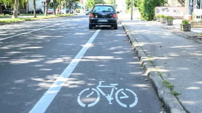
DC Backpedals on Bike Lane Protection, Swaps Barriers for Paint
Citing aesthetic concerns, the city is removing the concrete barriers and flexposts that once separated Arizona Avenue cyclists from motor vehicles.
Urban Design for Planners 1: Software Tools
This six-course series explores essential urban design concepts using open source software and equips planners with the tools they need to participate fully in the urban design process.
Planning for Universal Design
Learn the tools for implementing Universal Design in planning regulations.
Smith Gee Studio
City of Charlotte
City of Camden Redevelopment Agency
City of Astoria
Transportation Research & Education Center (TREC) at Portland State University
US High Speed Rail Association
City of Camden Redevelopment Agency
Municipality of Princeton (NJ)