Scientists in Florida are using GIS technology to strategically manage prescribed burns, aiding in the restoration and biodiversity of longleaf pine ecosystems while enhancing climate resilience across the Southeast.


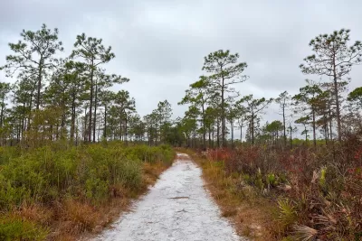
Longleaf pine ecosystems, once stretching across 90 million acres in the southeastern U.S., have dwindled to just three percent of their original size. These ecosystems are vital for biodiversity, housing over 600 species, including 29 that are endangered or threatened. As reported by Anthony Schultz and Sunny Fleming, scientists at Tall Timbers in Florida are using Geographic Information Systems (GIS) to manage longleaf pine restoration. By combining detailed environmental data with fire management practices, researchers are learning how prescribed burns help maintain the health and regeneration of these forests. Tall Timbers has been at the forefront of fire ecology for over 60 years, employing prescribed fire to manage ecosystems and enhance biodiversity.
At the core of the restoration is the Southeast FireMap, an innovative tool that integrates data from satellite imagery and artificial intelligence to track fire history and impacts across longleaf pine communities. By mapping areas that have burned, researchers can better understand the effects of fire on tree regeneration and overall ecosystem health. This approach, driven by data and field observations, allows land managers to strategically plan prescribed burns that mimic the natural fire cycles necessary for longleaf pine ecosystems to thrive. The digital twin technology also aids in tracking wildlife impacts and supports decision-making in managing these habitats.
In addition to restoring forests, Tall Timbers' efforts extend to public education and training, as they host the National Interagency Prescribed Fire Training Center. This center educates land managers from across the country on how to safely use fire to benefit ecosystems while minimizing risks like smoke pollution. Through collaborations and the use of cutting-edge GIS technology, Tall Timbers is advancing the preservation of longleaf pine forests, increasing biodiversity, and building climate resilience across the Southeast.
Read the full story: Tech Meets Ecology: Environmental Digital Twin Enhances Longleaf Pine Restoration


Fighting Forest Pests With AI: A Hemlock Success Story
Fairfax County utilized GeoAI and ArcGIS technology to efficiently map and protect its hemlock trees from the invasive woolly adelgid, ensuring targeted pest management and preservation of its evergreen canopy.

Oak Survival in the Great Lakes: Adapting to a Changing World
Climate change is endangering oaks in the Great Lakes region by increasing their vulnerability to pests, diseases, and extreme weather, threatening their vital ecological role.

How Data is Helping Protect Campus Trees
The University of Alabama at Birmingham is using GIS technology, student engagement, and sustainability-driven planning to manage and protect its nationally recognized urban forest.

Planetizen Federal Action Tracker
A weekly monitor of how Trump’s orders and actions are impacting planners and planning in America.

California plans to bury El Niño’s downpour
If the state plays its cards right, it may be able to store a billion acre-feet of El Niño’s water in aquifers.

Chicago breaks ground on $3 billion megadevelopment
The new neighborhood, titled Foundry Park, will one day host 3,700 residences.

California High-Speed Rail Authority CEO resigns after $600,000 scandal
Under Ian Choudri, the authority used taxpayer dollars to fund first class flights and trips to nightclubs.

Want to study the Missouri River? Soon, you may need unanimous approval from 10 states
Legislation would require 10 governors’ permission to study or build projects moving water outside the basin.

Desperate measures: Advocates weigh draining Lake Powell to fill Colorado River
Draining the reservoir could reduce evaporation losses by a couple hundred thousand acre-feet.

FREE Course: Walkable City 1: Why Walkability?
After describing his path towards focusing on walkability as the essence of good planning, Jeff Speck marches through his five principal reasons for making more walkable places.
Reinventing Malls: Planning Alchemy—Turning Gray Fields Into Gold
The course focuses on the opportunities and imperatives that shape reinvention of mall sites.

City of Rosemead
Rutgers University, Edward J. Bloustein School of Planning and Public Policy
One Hundred Miles
Hunter College, City University of New York (CUNY)
The Architects Foundation
University of Cincinnati Online
City of Cambridge
Montrose County
The Pocatello Development Authority