


An underused freeway exit ramp is now an inviting linear park that connects the city to the Hudson River.
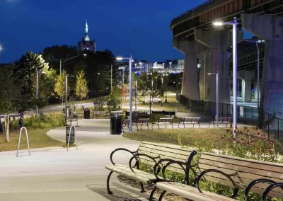
An underutilized former freeway ramp in Albany, New York was converted into a linear park, providing a model for how freeways and their surrounding infrastructure can be transformed into useful neighborhood amenities.
As Robert Steuteville explains in Congress for New Urbanism’s Public Square, “The $15 million Skyway—converting an Interstate ramp into a half-mile bike-ped corridor and park—realizes part of a long-held community vision to take back the waterfront as an accessible urban amenity,” writes Steuteville.
When first built, Interstate 787 displaced 7,000 residents and severed neighborhoods from the Hudson River. “Prior to the Skyway, reaching the waterfront from downtown required passage through public parking areas, a tangle of highway lanes, multiple signalized intersections, and unmarked and unlit walkways.”
The new park totals 3.3 acres and 2,680 feet in length from the intersection of Clinton Avenue and Broadway in downtown to US Route 9 by the river. Along the way are a 3,000 square foot outdoor art gallery, seating capacity for 600 people, 90,000 square feet of softscape park space with over 20,000 native plants and trees, and a 5,000-square-foot shaded area.
Steuteville adds, “The Skyway maximizes its limited resources by reclaiming an underutilized asset in a way that is aligned with Albany's vision for the future: an equitable and connected pedestrian and bicycle-friendly community.”
FULL STORY: Freeway ramp becomes park, connecting city to its river


Advocates Champion the Great Western Trail
A Chicago walking and biking trail along a former railroad right-of-way has been a labor of love for local residents.
San Jose Walk/Bike Trail Moves Forward
The new trail will offer key connections to a new BART station and other local trails.

Sioux Falls To Update Bike and Pedestrian Plans
The South Dakota city wants to encourage more biking and develop a comprehensive bike trail network.

Planetizen Federal Action Tracker
A weekly monitor of how Trump’s orders and actions are impacting planners and planning in America.

Maui's Vacation Rental Debate Turns Ugly
Verbal attacks, misinformation campaigns and fistfights plague a high-stakes debate to convert thousands of vacation rentals into long-term housing.

San Francisco Suspends Traffic Calming Amidst Record Deaths
Citing “a challenging fiscal landscape,” the city will cease the program on the heels of 42 traffic deaths, including 24 pedestrians.

Amtrak Rolls Out New Orleans to Alabama “Mardi Gras” Train
The new service will operate morning and evening departures between Mobile and New Orleans.

The Subversive Car-Free Guide to Trump's Great American Road Trip
Car-free ways to access Chicagoland’s best tourist attractions.

San Antonio and Austin are Fusing Into one Massive Megaregion
The region spanning the two central Texas cities is growing fast, posing challenges for local infrastructure and water supplies.
Urban Design for Planners 1: Software Tools
This six-course series explores essential urban design concepts using open source software and equips planners with the tools they need to participate fully in the urban design process.
Planning for Universal Design
Learn the tools for implementing Universal Design in planning regulations.
Heyer Gruel & Associates PA
JM Goldson LLC
Custer County Colorado
City of Camden Redevelopment Agency
City of Astoria
Transportation Research & Education Center (TREC) at Portland State University
Jefferson Parish Government
Camden Redevelopment Agency
City of Claremont