


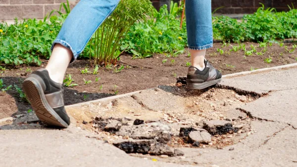
A new tool uses aerial image recognition to map a city’s sidewalks and crosswalks. Its developers hope it will aid in creating a more comprehensive understanding of pedestrian networks and where improvements are needed.

For many Americans, walking is an essential part of their daily trips to transit stops, schools, jobs, and other destinations. But as Peter Disikes explains for the MIT News Office, “Most cities and towns in the U.S. do not have sidewalk maps, and pedestrians are usually left to fend for themselves.”
Thanks to an effort led by researchers from MIT and other universities, “an open-source tool that uses aerial imagery and image-recognition to create complete maps of sidewalks and crosswalks” is now helping to bridge the information gap and provide planners and policymakers with a way to accurately assess the state of their city’s sidewalk network. “The tool, called TILE2NET, has been developed using a few U.S. areas as initial sources of data, but it can be refined and adapted for use anywhere.”
While many cities have incomplete sidewalk systems, advocating for expanding them is difficult without access to hard data. “The whole world of urban data for public transit and pedestrians and bicycles is really far behind [vehicle data] in quality. Analyzing how cities can be operational without a car requires this kind of data,” says Andres Sevtsuk, associate professor at MIT.
FULL STORY: Where the sidewalk ends

Portland Council Tentatively Approves Sidewalk Repair Plan
The proposal would address sidewalk needs in Portland’s District 1 and District 4.

Texas Bill Would Ban Road Diets, Congestion Pricing
A Texas state senator wants to prevent any discussion of congestion pricing and could suspend existing bike lane and sidewalk projects.

Denver Takes on Sidewalk Repair
The Colorado capital is the largest U.S. city to commit to maintaining its entire sidewalk network, funding repairs through a fee on property owners.

Maui's Vacation Rental Debate Turns Ugly
Verbal attacks, misinformation campaigns and fistfights plague a high-stakes debate to convert thousands of vacation rentals into long-term housing.

Planetizen Federal Action Tracker
A weekly monitor of how Trump’s orders and actions are impacting planners and planning in America.

In Urban Planning, AI Prompting Could be the New Design Thinking
Creativity has long been key to great urban design. What if we see AI as our new creative partner?

Massachusetts Budget Helps Close MBTA Budget Gap
The budget signed by Gov. Maura Healey includes $470 million in MBTA funding for the next fiscal year.

Milwaukee Launches Vision Zero Plan
Seven years after the city signed its Complete Streets Policy, the city is doubling down on its efforts to eliminate traffic deaths.

Portland Raises Parking Fees to Pay for Street Maintenance
The city is struggling to bridge a massive budget gap at the Bureau of Transportation, which largely depleted its reserves during the Civd-19 pandemic.
Urban Design for Planners 1: Software Tools
This six-course series explores essential urban design concepts using open source software and equips planners with the tools they need to participate fully in the urban design process.
Planning for Universal Design
Learn the tools for implementing Universal Design in planning regulations.
Gallatin County Department of Planning & Community Development
Heyer Gruel & Associates PA
JM Goldson LLC
City of Camden Redevelopment Agency
City of Astoria
Transportation Research & Education Center (TREC) at Portland State University
Jefferson Parish Government
Camden Redevelopment Agency
City of Claremont