


A large majority of Vancouver residents can access a grocery store in 15 minutes or less by bicycle or on foot.
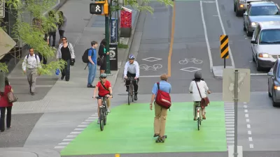
While the ‘15-minute city’—a neighborhood or city where residents can reach essential amenities in under 15 minutes without using a car—remains a long-term goal for many cities, in Vancouver, British Columbia, the concept is close to reality. Today, the majority of Vancouver residents can reach a grocery store within 15 minutes on bike or foot, reports Cheryl Chan for the Vancouver Sun.
According to a new study, “Nearly 80 per cent of Vancouver residents can get to a grocery store on foot or two wheels within that time frame, even assuming the slower travelling speeds of a senior.” Residents who bike are in luck: “Virtually all of the city had at least one grocery store a 15-minute bike ride away, while more than 75 per cent of the population with bikes has their pick of 10 or more grocery stores.”
For pedestrians, the numbers are still encouraging, but come with some caveats. “Among walkers, 91 per cent had access to at least one store within a 15-minute walk. That figure, however, is based on the walking speed of adults younger than 65 years old.” When calculated using a slower speed, the percentage of people that can’t reach a store within 15 minutes doubles from nine to 21 percent.
While the concept of an effective ‘15-minute city’ encompasses more than access to grocery stores, the article concludes that “Designing cities so that people can access their daily needs by foot or bike not only makes for a more inclusive city, but is also beneficial from a health and environmental perspective.”
FULL STORY: 15-minute city' within reach for Vancouver, SFU report says


What the ‘Walk Score’ Misses
A popular walkability assessment omits key factors that impact different demographics and can direct development resources to already wealthy neighborhoods.
Is the City Moving to the Suburbs?
Is the recent trend to build more walkable suburbs a sign of sustainable change?

The Changing Shape of American Suburbs
Housing costs and availability are pushing more American households, including young families, to suburbs and exurbs — and they’re demanding changes.

Maui's Vacation Rental Debate Turns Ugly
Verbal attacks, misinformation campaigns and fistfights plague a high-stakes debate to convert thousands of vacation rentals into long-term housing.

Planetizen Federal Action Tracker
A weekly monitor of how Trump’s orders and actions are impacting planners and planning in America.

In Urban Planning, AI Prompting Could be the New Design Thinking
Creativity has long been key to great urban design. What if we see AI as our new creative partner?

King County Supportive Housing Program Offers Hope for Unhoused Residents
The county is taking a ‘Housing First’ approach that prioritizes getting people into housing, then offering wraparound supportive services.

Researchers Use AI to Get Clearer Picture of US Housing
Analysts are using artificial intelligence to supercharge their research by allowing them to comb through data faster. Though these AI tools can be error prone, they save time and housing researchers are optimistic about the future.

Making Shared Micromobility More Inclusive
Cities and shared mobility system operators can do more to include people with disabilities in planning and operations, per a new report.
Urban Design for Planners 1: Software Tools
This six-course series explores essential urban design concepts using open source software and equips planners with the tools they need to participate fully in the urban design process.
Planning for Universal Design
Learn the tools for implementing Universal Design in planning regulations.
planning NEXT
Appalachian Highlands Housing Partners
Mpact (founded as Rail~Volution)
City of Camden Redevelopment Agency
City of Astoria
City of Portland
City of Laramie