


The city council voted to apply for a $1 million federal grant to study the potential benefits of building a park over downtown freeways.
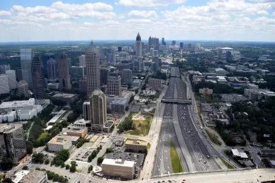
An Atlanta highway cap could finally become a reality, writes John Green. "Recent actions by the Atlanta City Council and Georgia legislators could lend hope for greenspace advocates that downtown’s grandiose, highway-capping 'Stitch' proposal still has a pulse."
Despite popular support, "[i]n more recent years, Stitch studies, panelist conferences, and calls among stakeholders for launching fundraising and engineering efforts haven’t translated to a shovel’s worth of dirt being turned. But with a transportation infrastructure push afoot in Washington, D.C., the Stitch concept is showing signs of renewed interest—and possible viability." To move the project forward, "the Atlanta City Council voted to move forward in applying for a $1 million federal grant that would help fund a study for implementing the Stitch, which advocates say would effectively weave interstate-bisected parts of downtown back together." However, "that federal cash boost would be a far cry from the Stitch’s estimated cost of $300 million or more, per ADID’s ongoing analyses. "
"But ADID officials are optimistic for what the Stitch could mean for downtown: between $1.1 and $3.1 billion in value creation; up to $58 million in new revenue; and a boost in the city’s bonding capacity from $308 to $847 billion 'by increasing the value of existing properties and catalyzing the redevelopment of underutilized properties,' per the most recent summary." The city is weighing creating a 25-acre park that would cap the I-75 and I-85 freeways and "reconnect neighborhoods torn apart by the interstate."
FULL STORY: Downtown's highway-capping 'Stitch' project shows signs of life

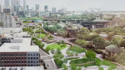
Atlanta Receives $3.2 Million for Freeway Cap Plan
The federal funding will help move forward planning for an ambitious proposal to cap a downtown Atlanta freeway with a 25-acre park.
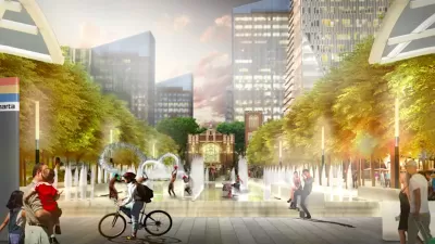
Atlanta Launches Website for Highway Cap Project
Residents can view plans for the 14-acre project that include public plazas and green spaces connecting local landmarks, employment centers, and transit stations.

Atlanta Weighs 'Midtown Connector' Freeway Cap
The billion-dollar project would create a 25-acre park and 3.5 miles of new bike and pedestrian routes.

Maui's Vacation Rental Debate Turns Ugly
Verbal attacks, misinformation campaigns and fistfights plague a high-stakes debate to convert thousands of vacation rentals into long-term housing.

Planetizen Federal Action Tracker
A weekly monitor of how Trump’s orders and actions are impacting planners and planning in America.

In Urban Planning, AI Prompting Could be the New Design Thinking
Creativity has long been key to great urban design. What if we see AI as our new creative partner?

King County Supportive Housing Program Offers Hope for Unhoused Residents
The county is taking a ‘Housing First’ approach that prioritizes getting people into housing, then offering wraparound supportive services.

Researchers Use AI to Get Clearer Picture of US Housing
Analysts are using artificial intelligence to supercharge their research by allowing them to comb through data faster. Though these AI tools can be error prone, they save time and housing researchers are optimistic about the future.

Making Shared Micromobility More Inclusive
Cities and shared mobility system operators can do more to include people with disabilities in planning and operations, per a new report.
Urban Design for Planners 1: Software Tools
This six-course series explores essential urban design concepts using open source software and equips planners with the tools they need to participate fully in the urban design process.
Planning for Universal Design
Learn the tools for implementing Universal Design in planning regulations.
planning NEXT
Appalachian Highlands Housing Partners
Mpact (founded as Rail~Volution)
City of Camden Redevelopment Agency
City of Astoria
City of Portland
City of Laramie