


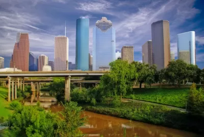
Bayou Greenways Park is part of a decade-long project building 172 miles of connected greenways around the city of Houston.
"[Y]ears of greener urban development led to this week’s opening of Bayou Greenways Park" in Houston, writes Andrew Dansby in the Houston Chronicle, adding another green spot to Houston's freeway-dominated downtown. "Bayou Greenways Park serves as a hub of sorts for Bayou Greenways 2020, a much larger, more ambitious 172-mile project that is roughly 122 miles into completion, with parks and paths around Brays, Buffalo, Greens, Halls, Hunting, Sims and White Oak Bayous, as well as the West Fork of the San Jacinto River."
Bayou Greenways "was designed to provide equitable access to park space across different parts of the city" and connect "neighborhoods via passageways that don’t require automobiles." But connecting the new greenways poses a major logistical challenge. Barron Wallace, Houston Parks Board chairman, says "getting a city to execute a plan like Bayou Greenways 2020 is like turning an aircraft carrier." Building greenways involves collaboration with stakeholders, transportation agencies, and the Harris County Flood Control District, among other entities.
"When the Bayou Greenways project is complete, it will bring an estimated 1.5 million Houstonians within 1.5 miles of green space" and open up new possibilities for Houstonians to explore and enjoy their city.
FULL STORY: Bayou Greenways Park opens this week as part of master plan for greener Houston

Public and Private Collaboration Advances Park Development in Houston
Houston may be known to some as a concrete jungle, but its greenspaces continue to expand thanks to combined support from the public, private, and philanthropic sectors.
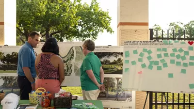
Tenderloin Greenway Closer to Reality
The Golden Gate Greenway will provide much-needed permanent park and community space in the dense neighborhood.

Urban Golf Courses: Publicly Subsidized, Privately Enjoyed
City golf courses, paid for by public dollars, are rarely used by the vast majority of residents. Some advocates want to see them opened to the public as parks or repurposed for housing.

Planetizen Federal Action Tracker
A weekly monitor of how Trump’s orders and actions are impacting planners and planning in America.

Restaurant Patios Were a Pandemic Win — Why Were They so Hard to Keep?
Social distancing requirements and changes in travel patterns prompted cities to pilot new uses for street and sidewalk space. Then it got complicated.

Maui's Vacation Rental Debate Turns Ugly
Verbal attacks, misinformation campaigns and fistfights plague a high-stakes debate to convert thousands of vacation rentals into long-term housing.

In California Battle of Housing vs. Environment, Housing Just Won
A new state law significantly limits the power of CEQA, an environmental review law that served as a powerful tool for blocking new development.

Boulder Eliminates Parking Minimums Citywide
Officials estimate the cost of building a single underground parking space at up to $100,000.

Orange County, Florida Adopts Largest US “Sprawl Repair” Code
The ‘Orange Code’ seeks to rectify decades of sprawl-inducing, car-oriented development.
Urban Design for Planners 1: Software Tools
This six-course series explores essential urban design concepts using open source software and equips planners with the tools they need to participate fully in the urban design process.
Planning for Universal Design
Learn the tools for implementing Universal Design in planning regulations.
Heyer Gruel & Associates PA
JM Goldson LLC
Custer County Colorado
City of Camden Redevelopment Agency
City of Astoria
Transportation Research & Education Center (TREC) at Portland State University
Jefferson Parish Government
Camden Redevelopment Agency
City of Claremont