


With constrained budgets, a geographic information system (GIS) may seem like a luxury for parks agencies. But to perform data-driven planning and advance park equity, GIS is an indispensable tool.

This pandemic has put a spotlight on parks and our need for them for our health and well-being. It has also made clear that not neighborhoods are created equal and that some are severely lacking in parks and recreational facilities where residents can exercise and relax.
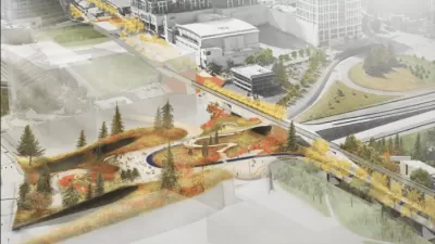
To address inequities in the distribution of parks and the funding needed to develop, operate, and maintain them, parks agencies are increasingly turning to GIS to help with planning, resource allocation, and decision-making. In this article, Los Angeles County planner Clement Lau explains how the Department of Parks and Recreation (DPR) has been using GIS. Specifically, he discusses the 2016 Los Angeles Countywide Parks Needs Assessment which was a historic and significant undertaking to engage cities and unincorporated communities within the county in a collaborative process to gather data and input to address data gaps and guide future decision-making on parks.
The Parks Needs Assessment was equity-focused and identified the communities with very high or high park need using GIS and the vast amount of data and public input collected through the process. Lau also shares that DPR has developed an internal user-friendly, web-based mapping and analysis tool called the Park Planning Viewer, which "effectively democratized GIS at DPR, enabling any staff to visualize and analyze parks data in relation to other layers of information, such as income, race/ethnicity, and various healthy indicators, and quickly prepare maps at their own computers." This tool is cost-effective because it saves DPR from having to buy individual GIS software licenses for all staff, and encourages all to think spatially, analytically, and comprehensively by having easy access to a variety of data.
The article demonstrates the increasing value of GIS as a planning tool and the importance of data to make informed decisions. As Lau explains, "Our ultimate goal is not only to produce pretty maps, it is about providing sound analysis that facilitates informed park planning, decision-making and resource allocation that benefit the communities we serve."
FULL STORY: Data-driven park planning: We all need green spaces to thrive. Data can make that happen


Rural Parks Planning Underway in Los Angeles County
The Los Angeles County Department of Parks and Recreation is conducting a survey to better understand the park and recreation needs of rural areas.
Poised for a New Era of Parks Planning in Bellevue, Washington
The last round of capital investment made possible by a 2008 parks levy offers a chance to look further into the future in Bellevue, Washington.
Building Healthier Communities: The Role of GIS in Park Planning
Integrating Geographic Information Systems (GIS) into park planning enhances community health by promoting physical activity, supporting mental well-being, fostering social connectedness, and addressing public health crises and climate change.

Planetizen Federal Action Tracker
A weekly monitor of how Trump’s orders and actions are impacting planners and planning in America.

Congressman Proposes Bill to Rename DC Metro “Trump Train”
The Make Autorail Great Again Act would withhold federal funding to the system until the Washington Metropolitan Area Transit Authority (WMATA), rebrands as the Washington Metropolitan Authority for Greater Access (WMAGA).

The Simple Legislative Tool Transforming Vacant Downtowns
In California, Michigan and Georgia, an easy win is bringing dollars — and delight — back to city centers.

The States Losing Rural Delivery Rooms at an Alarming Pace
In some states, as few as 9% of rural hospitals still deliver babies. As a result, rising pre-term births, no adequate pre-term care and harrowing close calls are a growing reality.

The Small South Asian Republic Going all in on EVs
Thanks to one simple policy change less than five years ago, 65% of new cars in this Himalayan country are now electric.

DC Backpedals on Bike Lane Protection, Swaps Barriers for Paint
Citing aesthetic concerns, the city is removing the concrete barriers and flexposts that once separated Arizona Avenue cyclists from motor vehicles.
Urban Design for Planners 1: Software Tools
This six-course series explores essential urban design concepts using open source software and equips planners with the tools they need to participate fully in the urban design process.
Planning for Universal Design
Learn the tools for implementing Universal Design in planning regulations.
Smith Gee Studio
City of Charlotte
City of Camden Redevelopment Agency
City of Astoria
Transportation Research & Education Center (TREC) at Portland State University
US High Speed Rail Association
City of Camden Redevelopment Agency
Municipality of Princeton (NJ)