


Issues of track blending and electrification factor heavily in the latest environmental impact report and environmental impact statement released last week for the California High-Speed Rail project.

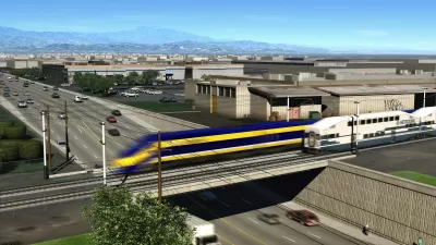
The California High-Speed Rail Authority released the Environmental IMpact Report (EIR/Environmental Impact States (EIS) for the San Francisco to San Jose Project Section of the California High-Speed Rail project on July 10, 2020, pursuant to state and federal environmental laws.
According to a website to share the documentation of the EIR/EIS, the recent EIR/EIS builds on a previous environmental review process that focused on Tiew 1 project level analysis. The Tier 2 project level analysis of the plan calls for the modernization of the rail corridor between San Francisco and San Jose and for service from the Salesforce Transit Center in San Francisco to the San Jose Diridon Station.
In San Francisco, HSR trains would stop at the 4th and King Street Station in San Francisco until the Transbay Joint Powers Authority completes its Downtown Extension Project, when HSR trains would stop at the Salesforce Transit Center in San Francisco.
Here's the big summary paragraph that introduces the scope of the EIR/EIS:
This Draft EIR/EIS evaluates the impacts and benefits of the No Project Alternative and two project alternatives (Alternative A and Alternative B). Each alternative includes HSR stations in San Francisco, Millbrae, and San Jose, and an [light maintenance facility] in Brisbane. The Authority’s Preferred Alternative under NEPA, which also serves as the proposed project for CEQA, is Alternative A, a predominantly two-track blended system with no additional passing track that includes service at one future station (Salesforce Transit Center, which would serve as an HSR station when the Transbay Joint Powers Authority completes its Downtown Extension Project), three existing Caltrain stations to be shared by HSR and Caltrain (4th and King Street [an interim station only], Millbrae, and San Jose Diridon), and the East Brisbane LMF. Alternative B is similar to Alternative A, but includes a 6-mile-long, four-track passing track between San Mateo and Redwood City, the West Brisbane LMF, and an aerial viaduct approaching the San Jose Diridon Station.
FULL STORY: SAN FRANCISCO TO SAN JOSE PROJECT SECTION DRAFT ENVIRONMENTAL IMPACT REPORT/ENVIRONMENTAL IMPACT STATEMENT

California High-Speed Rail Recommits to Bakersfield-to-Merced Segment
The California High-Speed Rail Authority also certified the Final Environmental Impact Report/Environmental Impact Statement for the San Francisco to San Jose section of the route in August.
Environmental Review Complete for Key Northern California Section of High-Speed Rail Project
The San Jose to Merced Project Section Final Environmental Impact Report/ Environmental Impact Statement could be approved by April 21.
A Change of Direction for California High-Speed Rail
In the face of political opposition and mounting construction costs in Southern California, the state High-Speed Rail Authority has chosen to build north from the Central Valley to San Jose rather than south from Fresno to the San Fernando Valley.

Maui's Vacation Rental Debate Turns Ugly
Verbal attacks, misinformation campaigns and fistfights plague a high-stakes debate to convert thousands of vacation rentals into long-term housing.

Planetizen Federal Action Tracker
A weekly monitor of how Trump’s orders and actions are impacting planners and planning in America.

Chicago’s Ghost Rails
Just beneath the surface of the modern city lie the remnants of its expansive early 20th-century streetcar system.

Bend, Oregon Zoning Reforms Prioritize Small-Scale Housing
The city altered its zoning code to allow multi-family housing and eliminated parking mandates citywide.

Amtrak Cutting Jobs, Funding to High-Speed Rail
The agency plans to cut 10 percent of its workforce and has confirmed it will not fund new high-speed rail projects.

LA Denies Basic Services to Unhoused Residents
The city has repeatedly failed to respond to requests for trash pickup at encampment sites, and eliminated a program that provided mobile showers and toilets.
Urban Design for Planners 1: Software Tools
This six-course series explores essential urban design concepts using open source software and equips planners with the tools they need to participate fully in the urban design process.
Planning for Universal Design
Learn the tools for implementing Universal Design in planning regulations.
planning NEXT
Appalachian Highlands Housing Partners
Mpact (founded as Rail~Volution)
City of Camden Redevelopment Agency
City of Astoria
City of Portland
City of Laramie