


Recent political interest in local land use regulations requires a thorough and nuanced understanding of the strengths and limitations of the methodologies available for measuring the effects of zoning.
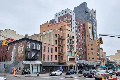
As noted in an article by Jenny Schuetz, both the Trump administration and a subset of the Democratic presidential candidates have proposed the removal of regulatory barriers to new development in the hopes of alleviating the nation's ongoing housing affordability crisis.
"But to design policies that are effective are reducing these barriers, we need to answer several questions," writes Schuetz. "How exactly does zoning drive up housing costs? How can we tell whether zoning is excessively restrictive?"
The answers to those questions and several that follow are "practically hard" to determine, according to Schuetz. "There isn’t one central database that contains all the thousands of local zoning codes, so most researchers conduct surveys of local planning officials. A few scholars have reviewed and manually coded laws, and there is increasing interest in using technical tools such as text analysis and machine learning….Each method has distinct strengths and limitations."
Schuetz provides examples of some of the research that have deployed those methodologies, before documenting another complication and suggesting a new frame for informing zoning reform in the name of housing affordability.
FULL STORY: Is zoning a useful tool or a regulatory barrier?


Atlanta to Tackle Affordability by Zoning Reform
A new initiative designed to implement the goals of the One Atlanta Housing Affordability Action Plan was announced last week in Atlanta.

A Pro-Development Approach to Housing Affordability and Economic Growth
Decades of building housing on the fringes of metropolitan areas have mired the United States in a housing affordability crisis defined by a widening gap between the haves and the have nots.

How Much Influence Can the Federal Government Have on the Housing Crisis?
A couple of questions are fundamental to the debate about the housing affordability crisis.

Planetizen Federal Action Tracker
A weekly monitor of how Trump’s orders and actions are impacting planners and planning in America.

Maui's Vacation Rental Debate Turns Ugly
Verbal attacks, misinformation campaigns and fistfights plague a high-stakes debate to convert thousands of vacation rentals into long-term housing.

San Francisco Suspends Traffic Calming Amidst Record Deaths
Citing “a challenging fiscal landscape,” the city will cease the program on the heels of 42 traffic deaths, including 24 pedestrians.

Amtrak Rolls Out New Orleans to Alabama “Mardi Gras” Train
The new service will operate morning and evening departures between Mobile and New Orleans.

The Subversive Car-Free Guide to Trump's Great American Road Trip
Car-free ways to access Chicagoland’s best tourist attractions.

San Antonio and Austin are Fusing Into one Massive Megaregion
The region spanning the two central Texas cities is growing fast, posing challenges for local infrastructure and water supplies.
Urban Design for Planners 1: Software Tools
This six-course series explores essential urban design concepts using open source software and equips planners with the tools they need to participate fully in the urban design process.
Planning for Universal Design
Learn the tools for implementing Universal Design in planning regulations.
Heyer Gruel & Associates PA
JM Goldson LLC
Custer County Colorado
City of Camden Redevelopment Agency
City of Astoria
Transportation Research & Education Center (TREC) at Portland State University
Jefferson Parish Government
Camden Redevelopment Agency
City of Claremont