


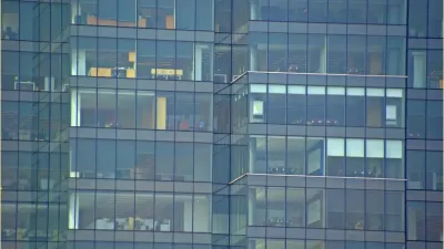
In New York City, tens of thousands of birds die each year after colliding with buildings. Policy and design measures can make the city much safer for its feathered inhabitants.

New York City Audubon estimates that between 90,000 and 230,000 birds are killed each year as the result of collisions with buildings in the city, reports Rachel Holliday Smith. "Experts say a few factors make certain buildings more deadly than others — including shiny, mirror-like surfaces near vegetation, which tricks birds into flying toward branches and leaves reflected in glass."
The organization tracks collisions through reports from volunteers, which means many collisions likely go unreported and parts of the city mistakenly appear relatively safe for birds. "Another reason collisions may happen a lot more in undercounted areas: Most bird deaths happen below the tree line — not on glass up high on a skyscraper," notes Smith.
Steps have been taken to better protect birds, including passage of a state bill for a panel focused on construction as well as pending local legislation that would require bird-safe features be incorporated into the design of newly constructed or altered buildings. "That could mean installing specially designed 'bird friendly' glass, creating a screen or barrier in front of glass or adding decals, stripes or dots to glass so birds know to steer clear," says Smith.
FULL STORY: CITY BUILDINGS KILL THOUSANDS OF BIRDS AS COUNCIL MULLS ‘FRIENDLY’ FACADES


Protecting Birds From Window Glass
Glass windows kill billions of birds each year. Simple fixes can help.

New York Largest U.S. City to Require Bird-Friendly Building Materials
The New York City Council approved Proposed Initiative 1482B by an overwhelming margin, ensuring bird-friendly design and construction practices in the largest U.S. city.
Why We're Not Meant to Live in Boring Cities
Features like blank street facades literally turn us off, decreasing mental stimulation and bringing on restlessness and stress. Research points to worrying consequences for people who find their city, well, boring.

Planetizen Federal Action Tracker
A weekly monitor of how Trump’s orders and actions are impacting planners and planning in America.

Maui's Vacation Rental Debate Turns Ugly
Verbal attacks, misinformation campaigns and fistfights plague a high-stakes debate to convert thousands of vacation rentals into long-term housing.

San Francisco Suspends Traffic Calming Amidst Record Deaths
Citing “a challenging fiscal landscape,” the city will cease the program on the heels of 42 traffic deaths, including 24 pedestrians.

Defunct Pittsburgh Power Plant to Become Residential Tower
A decommissioned steam heat plant will be redeveloped into almost 100 affordable housing units.

Trump Prompts Restructuring of Transportation Research Board in “Unprecedented Overreach”
The TRB has eliminated more than half of its committees including those focused on climate, equity, and cities.

Amtrak Rolls Out New Orleans to Alabama “Mardi Gras” Train
The new service will operate morning and evening departures between Mobile and New Orleans.
Urban Design for Planners 1: Software Tools
This six-course series explores essential urban design concepts using open source software and equips planners with the tools they need to participate fully in the urban design process.
Planning for Universal Design
Learn the tools for implementing Universal Design in planning regulations.
Heyer Gruel & Associates PA
JM Goldson LLC
Custer County Colorado
City of Camden Redevelopment Agency
City of Astoria
Transportation Research & Education Center (TREC) at Portland State University
Jefferson Parish Government
Camden Redevelopment Agency
City of Claremont