


The bridge was touted as a connection between downtown and the Mercedes-Benz Stadium, but it is more a reflection of the city’s misplaced fiscal and planning priorities.
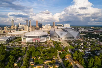
Sean Keenan writes that Atlanta’s Northside Drive pedestrian bridge was a fiscal boondoggle that highlights income inequality in the city. The bridge, which connects the Vine City neighborhood to the Mercedes-Benz Stadium, cost about $33 million to construct—$10 million more than initial cost estimates. And the bridge was supposed to be ready for the Super Bowl earlier this year, but it was not open to the public.
Keenan compares the pedestrian bridge to the 5th Street bridge in the Midtown area, which cost just over $10 million in 2004. "The 5th Street bridge repurposed an otherwise 'mediocre swath of concrete spanning the city’s vast Connector' into a complete streets success, replete with green space, seating, bike lanes, and wide sidewalks."
Keenan points out that building a costly pedestrian bridge to the stadium reflects the larger issue of the use of public funds in Atlanta. "Especially this summer, Atlanta has been criticized for prioritizing and subsidizing projects that make life more comfortable for motorists, sometimes at the expense of non-drivers," says Keenan.
FULL STORY: Report: Downtown pedestrian bridge shows city not built to foster equality

$1.9 Billion Public Financing Plan for Atlanta Mega-Project Headed to Appeal
The sage over The Gulch development project—soon to be renamed Centennial Yards—will continue after project opponents filed an appeal of a June court decision upholding public financing for the project.
Court Ruling Clears $1.9 Billion in Public Money for Atlanta Mega-Project
A $5 billion redevelopment project in Atlanta, named Centennial Yards, will receive substantial public support.

Sunday Fun: The Super Bowl in Atlanta on Social Media
Traffic and cars play a central role in the social media chatter surrounding the Super Bowl in Atlanta.

Maui's Vacation Rental Debate Turns Ugly
Verbal attacks, misinformation campaigns and fistfights plague a high-stakes debate to convert thousands of vacation rentals into long-term housing.

Planetizen Federal Action Tracker
A weekly monitor of how Trump’s orders and actions are impacting planners and planning in America.

In Urban Planning, AI Prompting Could be the New Design Thinking
Creativity has long been key to great urban design. What if we see AI as our new creative partner?

King County Supportive Housing Program Offers Hope for Unhoused Residents
The county is taking a ‘Housing First’ approach that prioritizes getting people into housing, then offering wraparound supportive services.

Researchers Use AI to Get Clearer Picture of US Housing
Analysts are using artificial intelligence to supercharge their research by allowing them to comb through data faster. Though these AI tools can be error prone, they save time and housing researchers are optimistic about the future.

Making Shared Micromobility More Inclusive
Cities and shared mobility system operators can do more to include people with disabilities in planning and operations, per a new report.
Urban Design for Planners 1: Software Tools
This six-course series explores essential urban design concepts using open source software and equips planners with the tools they need to participate fully in the urban design process.
Planning for Universal Design
Learn the tools for implementing Universal Design in planning regulations.
planning NEXT
Appalachian Highlands Housing Partners
Mpact (founded as Rail~Volution)
City of Camden Redevelopment Agency
City of Astoria
City of Portland
City of Laramie