


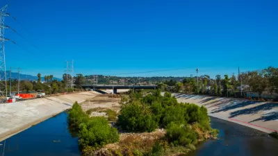
Three design proposals have been unveiled for the Taylor Yards parcel along the L.A. River.

A recent presentation detailed three design options for the Taylor Yards G2 Parcel on the Los Angeles River in the Glassell Park neighborhood. The 42-acre parcel is located on what was a Southern Pacific Railroad rail yard, and the project is one of several major restoration projects planned for the L.A. River.
One proposal would involve inserting a channel in the parcel to create a separated island open space. Another option would extend the river bed into the parcel and create a new flood plain. The third design involves focusing on the historical aspects of the site by recreating a roundhouse along with development of a wetlands.
All three designs would also include pedestrian bridges connecting the parcel to the west side of the river and a slew of new buildings throughout the park. Construction is slated to start in 2026, and completion of the project is scheduled for 2028.
FULL STORY: Three Design Options Emerge for the L.A. River Restoration's "Crown Jewel"


A New Master Plan for the Los Angeles River
The L.A. County Board of Supervisors voted to approved a new master plan for the L.A. River—the “Reimagined River.”
A Comment for the L.A. River Master Plan
Five themes proposed to achieve justice and sustainability for the Los Angeles River and its surrounding communities.

L.A. River Restoration Challenged by Gentrification, Environmental Concerns
A massive effort to restore the Los Angeles River to more public access and open space amentias continues to raise the specter of gentrification in neighborhoods already feeling the pressure of the housing market.

Planetizen Federal Action Tracker
A weekly monitor of how Trump’s orders and actions are impacting planners and planning in America.

Restaurant Patios Were a Pandemic Win — Why Were They so Hard to Keep?
Social distancing requirements and changes in travel patterns prompted cities to pilot new uses for street and sidewalk space. Then it got complicated.

Map: Where Senate Republicans Want to Sell Your Public Lands
For public land advocates, the Senate Republicans’ proposal to sell millions of acres of public land in the West is “the biggest fight of their careers.”

Maui's Vacation Rental Debate Turns Ugly
Verbal attacks, misinformation campaigns and fistfights plague a high-stakes debate to convert thousands of vacation rentals into long-term housing.

San Francisco Suspends Traffic Calming Amidst Record Deaths
Citing “a challenging fiscal landscape,” the city will cease the program on the heels of 42 traffic deaths, including 24 pedestrians.

California Homeless Arrests, Citations Spike After Ruling
An investigation reveals that anti-homeless actions increased up to 500% after Grants Pass v. Johnson — even in cities claiming no policy change.
Urban Design for Planners 1: Software Tools
This six-course series explores essential urban design concepts using open source software and equips planners with the tools they need to participate fully in the urban design process.
Planning for Universal Design
Learn the tools for implementing Universal Design in planning regulations.
Heyer Gruel & Associates PA
JM Goldson LLC
Custer County Colorado
City of Camden Redevelopment Agency
City of Astoria
Transportation Research & Education Center (TREC) at Portland State University
Camden Redevelopment Agency
City of Claremont
Municipality of Princeton (NJ)