


The New York Department of City Planning is keeping itself on the cutting edge of internet technology.
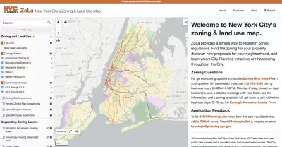
The New York Department of City Planning (DCP) recently announced updates to its Zoning and Land Use Application (ZoLa).
"ZoLa is a mapping tool that provides simple ways to research zoning regulations," according to a release announcing the upgrades.
Upgrades to the tool are intended to increase the tool's transparency, customization, and usefulness, with new functions like custom map creation, custom printing, street widths (previously available with the NYC Street Map), one-click access to the New York City Department of Housing Preservation and Development's Building, Registration, and Violation system, and easy access to special zoning district definitions.
The ZoLA upgrade is the latest in a string of web platform releases by DCP in recent years. Previous releases include ZAP Search, Zoning Resolution Online, Population Fact Finder, Community District Profiles, Metro Region Explorer, Waterfront Access Map, and NYC Street Map.
The in-house development team responsible for the ZoLa update, NYC Planning Labs, was recognized as a Planetizen Top Website in 2018.
FULL STORY: Increasing Transparency and Public Engagement: Department of City Planning Launches ZoLa 2.0


Opinion: Lower Rents Will Give Downtown Spaces Back to the ‘Weirdos’
Introducing the “CBGB theory of city planning.”

New York City Council Wants Community Engagement to Lead Affordable Housing Development
New York Mayor Eric Adams and City Council Speaker Adrienne Adams have proposed very different responses to the city’s lack of affordable housing.

A New Housing ‘Blueprint’ for New York City
With every new mayoral administration in New York City comes a new plan for addressing the city’s housing affordability crisis. Now it’s Mayor Adams’s turn.

Maui's Vacation Rental Debate Turns Ugly
Verbal attacks, misinformation campaigns and fistfights plague a high-stakes debate to convert thousands of vacation rentals into long-term housing.

Planetizen Federal Action Tracker
A weekly monitor of how Trump’s orders and actions are impacting planners and planning in America.

In Urban Planning, AI Prompting Could be the New Design Thinking
Creativity has long been key to great urban design. What if we see AI as our new creative partner?

Portland Raises Parking Fees to Pay for Street Maintenance
The city is struggling to bridge a massive budget gap at the Bureau of Transportation, which largely depleted its reserves during the Civd-19 pandemic.

Spokane Mayor Introduces Housing Reforms Package
Mayor Lisa Brown’s proposals include deferring or waiving some development fees to encourage more affordable housing development.

Houston Mayor Kills Another Bike Lane
The mayor rejected a proposed bike lane in the Montrose district in keeping with his pledge to maintain car lanes.
Urban Design for Planners 1: Software Tools
This six-course series explores essential urban design concepts using open source software and equips planners with the tools they need to participate fully in the urban design process.
Planning for Universal Design
Learn the tools for implementing Universal Design in planning regulations.
Gallatin County Department of Planning & Community Development
Heyer Gruel & Associates PA
JM Goldson LLC
City of Camden Redevelopment Agency
City of Astoria
Transportation Research & Education Center (TREC) at Portland State University
Jefferson Parish Government
Camden Redevelopment Agency
City of Claremont