


Fuel breaks involve clearing vegetation that feeds fires in order to prevent the catastrophic and fast-spreading wildfires that have plagued the state.
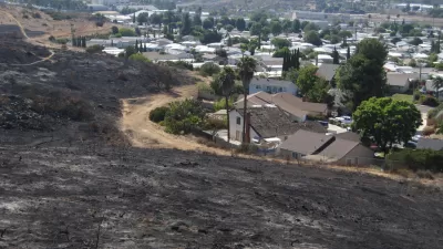
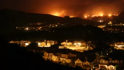
After last year’s devastating fires in California, communities throughout the state are looking to put in fuel breaks as a strategy against wildfire threats, report Katie Brown and Lisa M. Krieger:
The fuel breaks vary widely in size and shape. In forests, you may not even notice them: The trees’ leafy canopies are left intact, but the forest floor is cleaned up. In open areas, they resemble swaths of low vegetation. Along the sides of paved roads, 20 to 30 feet of vegetation is cleared.
Fuel breaks protect homes and buildings by stopping or slowing the spread of flames. But they also help firefighters access sites where fires are burning and can provide safe areas while they are battling blazes.
They have proven to be an effective way to reduce fire risks in areas where vegetation has built up. At $2,000 to $3,000 an acre, however, they are costly to build and require maintenance and substantial administrative legwork. Still, fighting fires is much more costly than prevention, say community advocates.
Governor Gavin Newsom has included $213.6 million in the state budget for programs to clear and reduce vegetation in vulnerable, fire-prone areas. "Newsom also wants to spend $4.5 million to create a new California Conservation Corps program devoted exclusively to making wild landscapes safer," note Brown and Krieger.
FULL STORY: Destruction of Paradise fire spurs rush to build fuel breaks

Housing Affordability and Worsening Wildfires: Twin Crises
As wildfires grow more destructive, how far should states go to protect homes located in high-risk areas?
More Colorado Suburbs at Risk for Wildfires
Experts warn that more intense fires fueled by a warming climate are threatening an increasing number of Colorado's suburban communities.
$536 Million for Wildfire Prevention Proposed in California
After a series of horrible fire seasons and another lackluster rainy season, the state of California is in need of new approaches to wildfire suppression and prevention.

Planetizen Federal Action Tracker
A weekly monitor of how Trump’s orders and actions are impacting planners and planning in America.

Restaurant Patios Were a Pandemic Win — Why Were They so Hard to Keep?
Social distancing requirements and changes in travel patterns prompted cities to pilot new uses for street and sidewalk space. Then it got complicated.

Map: Where Senate Republicans Want to Sell Your Public Lands
For public land advocates, the Senate Republicans’ proposal to sell millions of acres of public land in the West is “the biggest fight of their careers.”

Maui's Vacation Rental Debate Turns Ugly
Verbal attacks, misinformation campaigns and fistfights plague a high-stakes debate to convert thousands of vacation rentals into long-term housing.

San Francisco Suspends Traffic Calming Amidst Record Deaths
Citing “a challenging fiscal landscape,” the city will cease the program on the heels of 42 traffic deaths, including 24 pedestrians.

California Homeless Arrests, Citations Spike After Ruling
An investigation reveals that anti-homeless actions increased up to 500% after Grants Pass v. Johnson — even in cities claiming no policy change.
Urban Design for Planners 1: Software Tools
This six-course series explores essential urban design concepts using open source software and equips planners with the tools they need to participate fully in the urban design process.
Planning for Universal Design
Learn the tools for implementing Universal Design in planning regulations.
Heyer Gruel & Associates PA
JM Goldson LLC
Custer County Colorado
City of Camden Redevelopment Agency
City of Astoria
Transportation Research & Education Center (TREC) at Portland State University
Camden Redevelopment Agency
City of Claremont
Municipality of Princeton (NJ)