


A new report outlines a long list of measures the state needs to take to prevent catastrophic outcomes. However, it avoids directly discussing climate change as a cause of increasingly severe natural disasters.
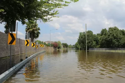
A new report from the Governor’s Commission to Rebuild Texas takes an in-depth look at the impacts of Hurricane Harvey as well as response and recovery efforts.
The report describes the $125 billion of damage left by Harvey, along with the tens of thousands of people who were displaced and the loss of over 12,000 structures. Proposed strategies include the elevation of homes, a buyout program to move residents located in high-risk flood zones, and protection of wetlands.
The report also recommends construction of an $8 billion barrier against storm surge. "To be composed of a 57-mile-long land barrier and two 22-foot-high movable gates, it would be built to protect residential and industrial areas in Galveston Bay and the Houston Ship Channel," says Anna Kuchment.
Critics, however, say the report does not do enough to address the role of climate change. "While the report, 'Eye of the Storm,' takes into account findings from climate scientists, including that sea levels are rising and storms are becoming more frequent and severe, nowhere does it explicitly mention climate change or its main underlying cause, the burning of fossil fuels," reports Kuchment.
FULL STORY: Hurricane Harvey report seeks to 'future-proof' Texas from climate change without saying so directly


Climate Resilience for an Aging Nation with Danielle Arigoni: The Planning Commission Podcast
Author and livability expert Danielle Arigoni talks about her new book with the Planning Commission Podcast.
Texas Grid Operator to Be Investigated by Congressional Subcommittee
Texas' costliest natural disaster will be the subject of a congressional investigation by a House Oversight subcommittee thanks to Rep. Ro Khanna, D-Calif., who is concerned about ERCOT's lack of preparation for extreme winter weather.
Adapting Building Codes to Natural Disasters Saves Billions
New research shows that modern building codes have prevented around $27 billion in damage from natural disasters between 2000 and 2016, yet many cities still operate under decades-old regulations.

Maui's Vacation Rental Debate Turns Ugly
Verbal attacks, misinformation campaigns and fistfights plague a high-stakes debate to convert thousands of vacation rentals into long-term housing.

Planetizen Federal Action Tracker
A weekly monitor of how Trump’s orders and actions are impacting planners and planning in America.

San Francisco Suspends Traffic Calming Amidst Record Deaths
Citing “a challenging fiscal landscape,” the city will cease the program on the heels of 42 traffic deaths, including 24 pedestrians.

Defunct Pittsburgh Power Plant to Become Residential Tower
A decommissioned steam heat plant will be redeveloped into almost 100 affordable housing units.

Trump Prompts Restructuring of Transportation Research Board in “Unprecedented Overreach”
The TRB has eliminated more than half of its committees including those focused on climate, equity, and cities.

Amtrak Rolls Out New Orleans to Alabama “Mardi Gras” Train
The new service will operate morning and evening departures between Mobile and New Orleans.
Urban Design for Planners 1: Software Tools
This six-course series explores essential urban design concepts using open source software and equips planners with the tools they need to participate fully in the urban design process.
Planning for Universal Design
Learn the tools for implementing Universal Design in planning regulations.
Heyer Gruel & Associates PA
JM Goldson LLC
Custer County Colorado
City of Camden Redevelopment Agency
City of Astoria
Transportation Research & Education Center (TREC) at Portland State University
Jefferson Parish Government
Camden Redevelopment Agency
City of Claremont