


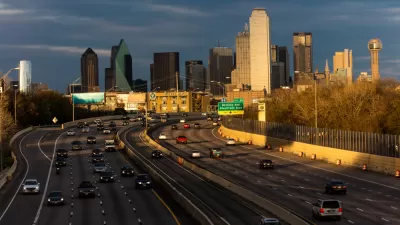
After a 2016 Texas Department of Transportation plan put forward a vision for a more walkable and dense city, TxDOT is still looking to expand I-30, a project that contradicts many of the forward-thinking ideas in that plan.
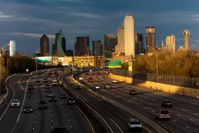
In a piece for D Magazine, Peter Simek argues that Dallas is a victim of overbuilt freeways that stratified the city and trapped many of its citizens in traffic. Simek writes, "Engineers at the agency have designed an I-30 expansion that doubles down on the same city-destroying mistakes of the past." In particular, the added capacity would pull people out of the city center and East Dallas. "The added or expanded frontage roads, widened overpasses, exit ramps, and surface streets will increase the speed of traffic through the neighborhoods adjacent to the highway," Simek writes.
Simek posits that the whole project is out of step with the internal goals of TxDOT. A 2016 plan called CityMAP outlined ways to make the city denser and more walkable. "If this newly engineered I-30 were constructed, many of the potential benefits laid out by the CityMAP study would be squandered," Simek writes.
FULL STORY: TxDOT’s Secret Plan to Destroy Downtown Dallas

The City of Dallas Rejects the State of Texas on Plans to Widen Interstate 30
A plan to widen the Interstate 30 in Dallas is pitting state transportation officials, with ostensible goals to serve regional transportation needs, against local officials, who are more concerned with "neighborhood-centric ideals."
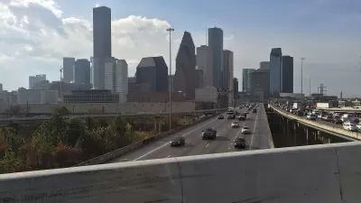
Contentious Houston Freeway Widening Project Inches Forward
Federal officials have given TxDOT the go-ahead to resume work on a small portion of a controversial interstate widening project in downtown Houston.

Austin Leaders Denounce 20-Lane Freeway Project
TxDOT is pushing ahead with plans for a massive freeway expansion project through downtown Austin despite opposition from virtually all local leaders.

Planetizen Federal Action Tracker
A weekly monitor of how Trump’s orders and actions are impacting planners and planning in America.

Maui's Vacation Rental Debate Turns Ugly
Verbal attacks, misinformation campaigns and fistfights plague a high-stakes debate to convert thousands of vacation rentals into long-term housing.

San Francisco Suspends Traffic Calming Amidst Record Deaths
Citing “a challenging fiscal landscape,” the city will cease the program on the heels of 42 traffic deaths, including 24 pedestrians.

Amtrak Rolls Out New Orleans to Alabama “Mardi Gras” Train
The new service will operate morning and evening departures between Mobile and New Orleans.

The Subversive Car-Free Guide to Trump's Great American Road Trip
Car-free ways to access Chicagoland’s best tourist attractions.

San Antonio and Austin are Fusing Into one Massive Megaregion
The region spanning the two central Texas cities is growing fast, posing challenges for local infrastructure and water supplies.
Urban Design for Planners 1: Software Tools
This six-course series explores essential urban design concepts using open source software and equips planners with the tools they need to participate fully in the urban design process.
Planning for Universal Design
Learn the tools for implementing Universal Design in planning regulations.
Heyer Gruel & Associates PA
JM Goldson LLC
Custer County Colorado
City of Camden Redevelopment Agency
City of Astoria
Transportation Research & Education Center (TREC) at Portland State University
Jefferson Parish Government
Camden Redevelopment Agency
City of Claremont