


Climate change is only part of the story, but humans have left a detectable footprint on the distribution of the global water supply.
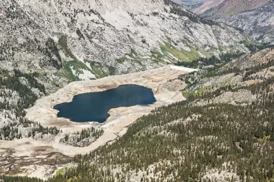
Eric Holthaus shares news of a new study that analyzes data from groundwater-detecting satellites. The results of the study, published in the journal Nature, are "equal parts terrifying and long-expected," according to Holthaus.
The authors used the satellite data to construct a map of 34 rapidly changing regions around the world, painting a unified picture of current hot spots of water scarcity and excess. Nearly every activity that involves people requires water — rice farming, nuclear power, aluminum smelting, you name it — so the lives of people living where reserves are being rapidly depleted are under grave threat.
According to Holthaus, the study makes the future threat of water scarcity abundantly clear.
FULL STORY: We can now see how humans have altered Earth’s water resources

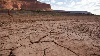
Researchers Propose the Concept of 'Anthropogenic Drought'
As climate change heightens the risk of intense drought periods, a new framework can help scientists better understand the interconnected causes and effects of drought.

Southern California's Water Conservation and Storage Efforts Paying Off
The region has poured over a billion dollars into storage infrastructure and demand management policies in anticipation of worsening drought conditions.
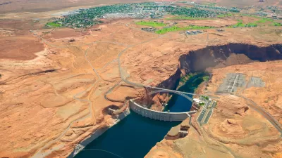
Drought Contingency Plan Triggered for the Colorado River
Signs of worsening drought conditions in the American West are triggering early actions for states that depend on water from the Colorado River.

Planetizen Federal Action Tracker
A weekly monitor of how Trump’s orders and actions are impacting planners and planning in America.

Maui's Vacation Rental Debate Turns Ugly
Verbal attacks, misinformation campaigns and fistfights plague a high-stakes debate to convert thousands of vacation rentals into long-term housing.

San Francisco Suspends Traffic Calming Amidst Record Deaths
Citing “a challenging fiscal landscape,” the city will cease the program on the heels of 42 traffic deaths, including 24 pedestrians.

Amtrak Rolls Out New Orleans to Alabama “Mardi Gras” Train
The new service will operate morning and evening departures between Mobile and New Orleans.

The Subversive Car-Free Guide to Trump's Great American Road Trip
Car-free ways to access Chicagoland’s best tourist attractions.

San Antonio and Austin are Fusing Into one Massive Megaregion
The region spanning the two central Texas cities is growing fast, posing challenges for local infrastructure and water supplies.
Urban Design for Planners 1: Software Tools
This six-course series explores essential urban design concepts using open source software and equips planners with the tools they need to participate fully in the urban design process.
Planning for Universal Design
Learn the tools for implementing Universal Design in planning regulations.
Heyer Gruel & Associates PA
JM Goldson LLC
Custer County Colorado
City of Camden Redevelopment Agency
City of Astoria
Transportation Research & Education Center (TREC) at Portland State University
Jefferson Parish Government
Camden Redevelopment Agency
City of Claremont