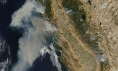
The fires in Northern California have caused at least 21 deaths, with over 500 people missing in Sonoma County. Wired science editor, Adam Rogers, looks at the problems posed when urban development encroaches wildlands.


Take a video train ride through what once were Santa Rosa neighborhoods on Sonoma–Marin Area Rail Transit (SMART), courtesy of the San Francisco Chronicle, Oct. 10.
"According to CAL FIRE spokeswoman Heather Williams, 11 people have died in Sonoma County, six in Mendocino County, two in Yuba County and two in Napa County," report Phil Willon, Paige St. John, Louis Sahagun, Sonali Kohli and Chris Megerian for the Los Angeles Times on Wednesday.
"We've had big fires in the past," Gov. Jerry Brown said. "This is one of the biggest."
Cal Fire estimates that around 3,500 structures have been destroyed.
As of noon, Wednesday, over 500 people were reported missing in Sonoma County, according to the San Francisco Chronicle.
Strong winds spread the fires rapidly – which Adam Rogers, science editor for Wired, mentions in his Oct. 11 piece that looks at the wildland-urban interface (WUI).
Blame the wind, if you want. In Southern California they call it the Santa Ana; in the north, the Diablos.
No one yet knows the cause of the more than a dozen fires ablaze around California, but fires start where humans meet the wild forests, where people build for solitude or space or beauty. Things go wrong in those liminal spaces, at the interface between the wilds and the built.
The location of the WUI presents special challenges for firefighters from both sides of the interface.
“Most wildland firefighters are not trained in structural protection, but the urban fire departments are not trained to deal with dozens or hundreds of houses burning at the same time,” says Volker Radeloff, a forestry researcher at the University of Wisconsin. “When these areas with lots of houses burn, the fires become very unpredictable.”
Housing crisis exacerbates fire potential
California housing policies are more likely to push single-family houses out into the edges of communities than encourage the construction of dense city centers.
So keep thinking about blame as northern California rebuilds—if regulations get brave enough to insist on denser cities, less flammable materials, different ornamental vegetation, underground power lines.
For more focus on the WUI nexus with California's housing shortage, see August post by contributing editor Philip Rojc based on an earlier Wired article by Rogers, and September 2016 post from The Wall Street Journal.
Air Quality
The smoke from the North Bay fires have worsened air quality in San Francisco and the Peninsula, reports Amy Graff for The Chronicle.
"We're seeing the worst air quality ever recorded in many parts of the Bay Area," says Tom Flannigan, the [public information officer] for the Bay Area Air Quality Management District. "The entire Bay Area population is likely being affected by the smoke."
The wet winter and climate change may also help explain the intensity of recent fires.
More reading on wildland-urban interface:
- See August 2016 post to read how "Strategic Land Use Planning Could Lower the Cost of Wildfires."
- U.S. Forest Service publication (2013): "Wildfire, Wildlands, and People: Understanding and Preparing for Wildfire in the Wildland-Urban Interface." [pdf]:
This report by the Forests on the Edge project, sponsored by the U.S. Department of Agriculture, Forest Service is intended to heighten awareness of the ecological role and societal costs of wildfire, the causes and impacts of wildfire on human communities, and the relationship between increases in housing development and wildfire risk.
Read the full story: The Napa Fire Is A Perfectly Normal Apocalypse


New Commuter Train Comes Through for Fire-Ravaged Santa Rosa
Sonoma-Marin Rail Transit (SMART) has been operating almost continuously at full schedule, collecting no fares since the epic wildfires began in Sonoma County on Oct. 8. Two stations in the fire-zone are shut down due to lack of access.

Wine Country Wildfires Put Spotlight on Transmission Lines
No cause has yet been attributed to California's deadliest wildfires, but the connections to fallen power lines and exploding transformers, maintained by PG&E, have been exposed in a series of reports by the Bay Area News Group.

California Population Grows to 39,810,000 in 2017
California added 309,000 residents last year, an 8 percent drop compared to annual increases since 2010. The state added a net 85,000 housing units, accounting for losses to wildfires.

Planetizen Federal Action Tracker
A weekly monitor of how Trump’s orders and actions are impacting planners and planning in America.

California plans to bury El Niño’s downpour
If the state plays its cards right, it may be able to store a billion acre-feet of El Niño’s water in aquifers.

Chicago breaks ground on $3 billion megadevelopment
The new neighborhood, titled Foundry Park, will one day host 3,700 residences.

California High-Speed Rail Authority CEO resigns after $600,000 scandal
Under Ian Choudri, the authority used taxpayer dollars to fund first class flights and trips to nightclubs.

Want to study the Missouri River? Soon, you may need unanimous approval from 10 states
Legislation would require 10 governors’ permission to study or build projects moving water outside the basin.

Desperate measures: Advocates weigh draining Lake Powell to fill Colorado River
Draining the reservoir could reduce evaporation losses by a couple hundred thousand acre-feet.

FREE Course: Walkable City 1: Why Walkability?
After describing his path towards focusing on walkability as the essence of good planning, Jeff Speck marches through his five principal reasons for making more walkable places.
Reinventing Malls: Planning Alchemy—Turning Gray Fields Into Gold
The course focuses on the opportunities and imperatives that shape reinvention of mall sites.

City of Rosemead
Rutgers University, Edward J. Bloustein School of Planning and Public Policy
One Hundred Miles
Hunter College, City University of New York (CUNY)
The Architects Foundation
University of Cincinnati Online
City of Cambridge
Montrose County
The Pocatello Development Authority