


The West Santa Ana Branch light rail would offer new infrastructure and economic activity to a transit-dependent part of the county.
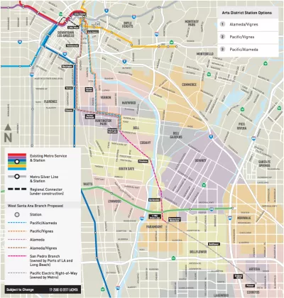
Named for an old Pacific Electric line, the West Santa Ana Branch Transit Corridor would take one of four possible routes spanning about 20 miles from Artesia to Downtown L.A.'s Union Station. With a projected ridership of at least 80,000, it would be one of the busiest light rail lines in the country.
Twelve cities, plus the Hollywood-Burbank Airport, are managing the project through a JPA called Eco-Rapid Transit, headed by transportation planner Michael Kodama. In The Planning Report, Kodama explains the JPA's holistic view of the rail line as a mechanism to bolster economic development and connectivity along the length of the corridor, noting the opportunity to fill other infrastructure gaps in the project area.
"This project serves an area of Los Angeles County that is, frankly, underserved," he says. "It goes through the industrial and manufacturing heart of the county, where a lot of folks don’t have high incomes and have big transit needs."
Metro's Office of Extraordinary Innovation recently greenlit an unsolicited proposal for a public-private partnership that could condense the entire project into one phase. It would be the first P3 of its kind in L.A., Kodama says. He speaks more about funding, equity, and the economic impacts of the project in TPR.
FULL STORY: Eco-Rapid Transit: Metro Light Rail to Connect Southeast County & DTLA

$4.3 Billion Awarded to California Transformative Projects from Gas Tax and Climate Fund
Two difficult votes last year, both requiring super-majorities, are paying huge dividends to 28 transformative projects throughout the Golden State to improve rail and transit service and reduce greenhouse gas emissions.

L.A. Metro CEO Challenges Trump on Infrastructure Funding
President Trump’s most recent transportation budget is projected to cut transportation spending by 13 percent, potentially undercutting many of Los Angeles' ambitious projects to continue the build-out of a full public transportation system.
Auto Companies Prepare for Decline of Car Ownership
It's no longer just transit agencies that are trying to meet the first mile-last mile challenge—auto companies have also jumped in by offering "mobility services." And it's more profitable than selling cars!

Maui's Vacation Rental Debate Turns Ugly
Verbal attacks, misinformation campaigns and fistfights plague a high-stakes debate to convert thousands of vacation rentals into long-term housing.

Planetizen Federal Action Tracker
A weekly monitor of how Trump’s orders and actions are impacting planners and planning in America.

In Urban Planning, AI Prompting Could be the New Design Thinking
Creativity has long been key to great urban design. What if we see AI as our new creative partner?

King County Supportive Housing Program Offers Hope for Unhoused Residents
The county is taking a ‘Housing First’ approach that prioritizes getting people into housing, then offering wraparound supportive services.

Researchers Use AI to Get Clearer Picture of US Housing
Analysts are using artificial intelligence to supercharge their research by allowing them to comb through data faster. Though these AI tools can be error prone, they save time and housing researchers are optimistic about the future.

Making Shared Micromobility More Inclusive
Cities and shared mobility system operators can do more to include people with disabilities in planning and operations, per a new report.
Urban Design for Planners 1: Software Tools
This six-course series explores essential urban design concepts using open source software and equips planners with the tools they need to participate fully in the urban design process.
Planning for Universal Design
Learn the tools for implementing Universal Design in planning regulations.
planning NEXT
Appalachian Highlands Housing Partners
Mpact (founded as Rail~Volution)
City of Camden Redevelopment Agency
City of Astoria
City of Portland
City of Laramie