Washington Park is described as the jewel in the crown of Portland's park system. The city recently updated its master plan for the first time since 1981.


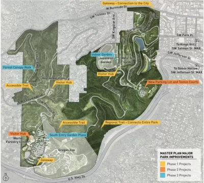
The city of Portland recently approved the Washington Park Master Plan, which addresses the long-term sustainability of the 481-acre park located just west of Downtown and the Pearl District in Portland's central city. According to the city website set up to detail the planning process, "the Washington Park Master Plan Update focuses on three major areas of improvement for the long-term sustainability of the 481-acre park: create identity, improve access, and enhance the visitor experience."
Jonathan Maus writes in support of the plan a few days after the Portland City Council adopted the master plan update, voicing support for the plan's transportation. Maus summarizes the transportation elements of the master plan as follows: "[to] keep cars on the periphery, reduce access for drivers, aggressively encourage transit use, create plaza and green spaces, and build protected paths for cycling and walking." The article includes more details about how the plan intends to attain that vision.
An article by Sam McCaffrey provides additional insight into the plan.
FULL STORY: Carfree Kingston, a rail-trail path and more: New plan puts Washington Park’s future in focus

All We Want for the Holidays is…
Here are a dozen timely gift ideas for creating better communities.
Draft West Portland Town Center Plan Seeks Public Comment
Always a closely watched planning jurisdiction, Portland, Oregon is proceeding with a new vision for the future of the western end of the city.

Rural Parks Planning Underway in Los Angeles County
The Los Angeles County Department of Parks and Recreation is conducting a survey to better understand the park and recreation needs of rural areas.

The state-sanctioned urbicide of Austin
People don’t kill cities. Freeways do.

US to reduce Colorado River water deliveries to Mexico
A new Colorado Treaty amendment reduces Mexico’s Colorado River water allocation by 250,000 acre feet.

New Jersey’s second-largest city bans standalone data centers
Jersey City will continue to allow co-location facilities, such as those meant for research institutions that store their own data.

Amtrak not solely to blame for New Jersey commuter rail's unreliability, report finds
A new study from the Garden State Initiative found that NJ Transit’s budget grew 20% across a 4 year period, but reliability declined significantly over the same period.

EPA erases limits on planet-warming pollution from power plants
Under Monday’s plan, power plants would still have some limits on how much mercury, arsenic and other contaminants they can emit.

Phoenix announces new on-demand transit service, more frequent RAPID buses
Both new services will launch in October, and are part of Phoenix's Project Effective Access Solutions for Easing Congestion.

FREE Course: Walkable City 1: Why Walkability?
After describing his path towards focusing on walkability as the essence of good planning, Jeff Speck marches through his five principal reasons for making more walkable places.
Reinventing Malls: Planning Alchemy—Turning Gray Fields Into Gold
The course focuses on the opportunities and imperatives that shape reinvention of mall sites.

Eagle County Government
Harvard University Graduate School of Design
Nashville Planning Department
The Architects Foundation
University of Cincinnati Online
The Pocatello Development Authority
The Urban Renewal Agency of the City of Pocatello
Journal of the American Planning Association