


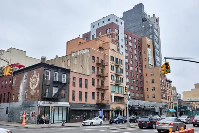
Many cities require the owners of multistory buildings to regularly inspect their façades, looking for problems that may lead to injury or property damage. Drones can potentially help ease the process and cost of doing so.
Why is this important? What are the potential implications for the built environment?
Many cities require the owners of multistory buildings to regularly inspect their façades, looking for problems that may lead to injury or property damage — loose masonry at risk of crashing to the sidewalk below, for instance.
These investigations are typically conducted in two stages. In the first, inspectors located on the ground or in adjacent buildings use binoculars to conduct a visual inspection. In the second, they study the façade up close, performing physical tests as needed.
The second stage often requires costly and disruptive interventions to the building and the surrounding neighborhood. Since many buildings lack the equipment needed to safely lower inspectors down the façade, owners frequently erect scaffolding that can block signage, views, and pedestrian pathways — sometimes for weeks on end, depending on the building’s size.
Finding a way to improve the first stage of the inspection in order to shorten the duration of the second could make these studies much cheaper and less invasive. It could also improve inspector safety, reducing the need for climbing around scaffolding or rappeling down the side of buildings.
FULL STORY: Can drones inspect urban building facades?


Maui's Vacation Rental Debate Turns Ugly
Verbal attacks, misinformation campaigns and fistfights plague a high-stakes debate to convert thousands of vacation rentals into long-term housing.

Planetizen Federal Action Tracker
A weekly monitor of how Trump’s orders and actions are impacting planners and planning in America.

San Francisco Suspends Traffic Calming Amidst Record Deaths
Citing “a challenging fiscal landscape,” the city will cease the program on the heels of 42 traffic deaths, including 24 pedestrians.

Defunct Pittsburgh Power Plant to Become Residential Tower
A decommissioned steam heat plant will be redeveloped into almost 100 affordable housing units.

Trump Prompts Restructuring of Transportation Research Board in “Unprecedented Overreach”
The TRB has eliminated more than half of its committees including those focused on climate, equity, and cities.

Amtrak Rolls Out New Orleans to Alabama “Mardi Gras” Train
The new service will operate morning and evening departures between Mobile and New Orleans.
Urban Design for Planners 1: Software Tools
This six-course series explores essential urban design concepts using open source software and equips planners with the tools they need to participate fully in the urban design process.
Planning for Universal Design
Learn the tools for implementing Universal Design in planning regulations.
Heyer Gruel & Associates PA
JM Goldson LLC
Custer County Colorado
City of Camden Redevelopment Agency
City of Astoria
Transportation Research & Education Center (TREC) at Portland State University
Jefferson Parish Government
Camden Redevelopment Agency
City of Claremont