


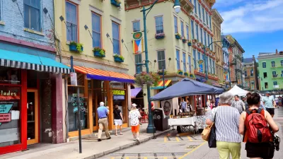
Researchers at MIT and Harvard believe that their computer vision system (i.e., artificial intelligence) helps reveal fundamental characteristics of neighborhood change.
Larry Hardesty shares news of a new "computer vision system" from MIT's Media Lab, created with partners from Harvard University, that quantifies "the physical improvement or deterioration of neighborhoods in five American cities."
In work reported today in the Proceedings of the National Academy of Sciences, the system compared 1.6 million pairs of photos taken seven years apart. The researchers used the results of those comparisons to test several hypotheses popular in the social sciences about the causes of urban revitalization. They find that density of highly educated residents, proximity to central business districts and other physically attractive neighborhoods, and the initial safety score assigned by the system all correlate strongly with improvements in physical condition.
The new tool is built on a system created four years ago, which analyzes "street-level photos taken in urban neighborhoods in order to gauge how safe the neighborhoods would appear to human observers."
Hardesty goes into a lot more detail about the ideas that contributed to the creation of the computer vision system, and the findings that have been produced in its deployment.
Linda Poon offers additional insight into the use of artificial intelligence in the analysis of urban conditions.
FULL STORY: Why do some neighborhoods improve?

Black Residents Leaving Cincinnati's Fast Growing Urban Area
The housing market in the neighborhood of Over-the-Rhine is a 'segregation machine.'
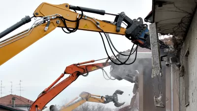
$160 Million in Bond Funding for Demolitions on the Ballot in Detroit
Proposal N, on the ballot for Detroit voters next week, will provide $160 million in bond funding for demolitions and $90 million to mothball homes for future rehab, but, according to this opinion, it won't solve the city's blight challenges.

Revitalization Without Displacement: A New Model From Miami
Upzonings in working class neighborhoods usually provoke political opposition based on concerns about gentrification and displacement. But the new Wynwood Norte Neighborhood Revitalization District in Miami might have worked for a solution.

Planetizen Federal Action Tracker
A weekly monitor of how Trump’s orders and actions are impacting planners and planning in America.

Chicago’s Ghost Rails
Just beneath the surface of the modern city lie the remnants of its expansive early 20th-century streetcar system.

San Antonio and Austin are Fusing Into one Massive Megaregion
The region spanning the two central Texas cities is growing fast, posing challenges for local infrastructure and water supplies.

Since Zion's Shuttles Went Electric “The Smog is Gone”
Visitors to Zion National Park can enjoy the canyon via the nation’s first fully electric park shuttle system.

Trump Distributing DOT Safety Funds at 1/10 Rate of Biden
Funds for Safe Streets and other transportation safety and equity programs are being held up by administrative reviews and conflicts with the Trump administration’s priorities.

German Cities Subsidize Taxis for Women Amid Wave of Violence
Free or low-cost taxi rides can help women navigate cities more safely, but critics say the programs don't address the root causes of violence against women.
Urban Design for Planners 1: Software Tools
This six-course series explores essential urban design concepts using open source software and equips planners with the tools they need to participate fully in the urban design process.
Planning for Universal Design
Learn the tools for implementing Universal Design in planning regulations.
planning NEXT
Appalachian Highlands Housing Partners
Mpact (founded as Rail~Volution)
City of Camden Redevelopment Agency
City of Astoria
City of Portland
City of Laramie