


Researchers from the United States Geological Survey (USGS) have produced a model of coastal erosion based on the impacts of expected sea level rise by the end of the century.

The Associated Press reports the findings of a new prediction model produced by the Coastal Storm Modeling System (CoSMoS) that predicts dramatic impacts for the coastal beaches of Southern California. The new study says that sea level rise could erode between 31 and 67 percent of beaches—erosion back to the point of coastal infrastructure or the sea cliffs that make up much of the coast.
The USGS released the study, which has also been accepted by the American Geophysical Union's Journal of Geophysical Research: Earth Surface. The USGS website provides additional information on the study. The percentages listed above only tell part of the story: "future predictions indicate that nearly all of the beaches will experience erosion (will get smaller) due to accelerated sea-level rise."
The USGS website also notes the critical role of beaches in the Southern California economy. USGS geologist and study co-author Patrick Barnard is quoted saying, "we will have to perform massive and costly interventions to preserve these beaches in the future under the erosive pressures of anticipated sea level rise, or risk losing many of the economic and protective benefits beaches provide."
FULL STORY: Disappearing Beaches: Modeling Shoreline Change in Southern California


SoCal Leaders Debate Moving Coastal Rail Line
Train tracks running along the Pacific Ocean are in danger from sea level rise, but residents are divided on how to fix the problem.
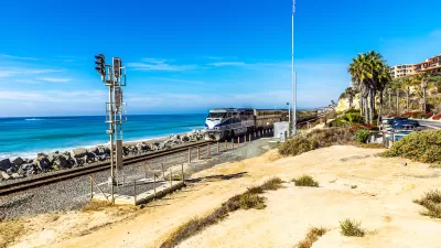
Storms Sever California Rail Line—Again
The coast-hugging rail corridor linking Los Angeles and San Diego faces an uncertain future as mudslides once again force part of the line to close.

Southern California Rail Corridor In Danger From Erosion, Lack of Leadership
With a patchwork of management and local agencies involved, the imperiled rail corridor has no unified plan for improving or relocating tracks impacted by coastal erosion.

Maui's Vacation Rental Debate Turns Ugly
Verbal attacks, misinformation campaigns and fistfights plague a high-stakes debate to convert thousands of vacation rentals into long-term housing.

Planetizen Federal Action Tracker
A weekly monitor of how Trump’s orders and actions are impacting planners and planning in America.

In Urban Planning, AI Prompting Could be the New Design Thinking
Creativity has long been key to great urban design. What if we see AI as our new creative partner?

King County Supportive Housing Program Offers Hope for Unhoused Residents
The county is taking a ‘Housing First’ approach that prioritizes getting people into housing, then offering wraparound supportive services.

Researchers Use AI to Get Clearer Picture of US Housing
Analysts are using artificial intelligence to supercharge their research by allowing them to comb through data faster. Though these AI tools can be error prone, they save time and housing researchers are optimistic about the future.

Making Shared Micromobility More Inclusive
Cities and shared mobility system operators can do more to include people with disabilities in planning and operations, per a new report.
Urban Design for Planners 1: Software Tools
This six-course series explores essential urban design concepts using open source software and equips planners with the tools they need to participate fully in the urban design process.
Planning for Universal Design
Learn the tools for implementing Universal Design in planning regulations.
planning NEXT
Appalachian Highlands Housing Partners
Gallatin County Department of Planning & Community Development
Mpact (founded as Rail~Volution)
City of Camden Redevelopment Agency
City of Astoria
City of Portland
City of Laramie