


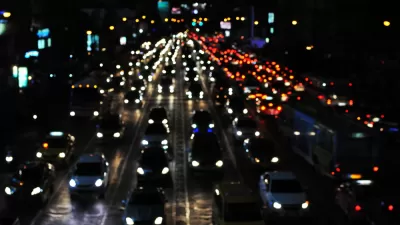
The networked sensors and signals in Ann Arbor give the city a coordinated way to respond to traffic.

We've all thought, "Why is there a light here?" when stuck waiting for a signal to change on an empty street. In Ann Arbor that frustration may be going away. "To combat congestion, each hopped-up signal uses pavement-embedded sensors or cameras to spot cars waiting at red lights. The signals send that information via fiber network to the Big Computer back at traffic management base, which compiles the data," Aarian Marshall reports for Wired. This technology has already been implemented in cities big and small around the world, but the Ann Arbor system takes the application further. "If there are four cars lined up to go one way through an intersection, and zero cars lined up to move perpendicular to them, the light might turn green for the four. But a network of connected lights—like in Ann Arbor—will analyze the entire grid, and figure out who to prioritize to get the most people to their destinations the fastest," Marshall writes.
While this technology can alleviate some inefficiencies in commuting, it can only go so far in speeding up automotive transit times. "Geometry says there are only so many ways to fit a bunch of vehicles on to streets," Marshall writes. Further, the phenomenon of induced demand will likely cause new drivers to take up the slack the system creates.
FULL STORY: Ann Arbor Is Fighting Traffic With Software—and Winning


Research Shows More Roads = More Driving
A national study shows, once again, that increasing road supply induces additional vehicle travel, particularly over the long run.

Why Traffic Never Gets Better
Despite abundant research showing that roadway expansions provide limited congestion relief and increase long-term traffic problems, they still occur due to wishful thinking: advocates claim that “this” project is different.
Congestion Growing in Sunbelt Cities
Cities with rapidly growing populations and inadequate public transit systems are seeing more gridlock despite changes in commuting patterns and the rise of remote work.

Planetizen Federal Action Tracker
A weekly monitor of how Trump’s orders and actions are impacting planners and planning in America.

Maui's Vacation Rental Debate Turns Ugly
Verbal attacks, misinformation campaigns and fistfights plague a high-stakes debate to convert thousands of vacation rentals into long-term housing.

Cuomo Is the Candidate of Both NIMBYs and Developers. What Gives?
In the New York City mayoral race, odd bedfellows align to preserve the housing status quo.

The Subversive Car-Free Guide to Trump's Great American Road Trip
Car-free ways to access Chicagoland’s best tourist attractions.

San Antonio and Austin are Fusing Into one Massive Megaregion
The region spanning the two central Texas cities is growing fast, posing challenges for local infrastructure and water supplies.

Charlottesville Temporarily Has No Zoning Code
A judge ordered the Virginia city to throw out its newly revised zoning code, leaving permitting for new development in legal limbo.
Urban Design for Planners 1: Software Tools
This six-course series explores essential urban design concepts using open source software and equips planners with the tools they need to participate fully in the urban design process.
Planning for Universal Design
Learn the tools for implementing Universal Design in planning regulations.
Heyer Gruel & Associates PA
JM Goldson LLC
Custer County Colorado
City of Camden Redevelopment Agency
City of Astoria
Transportation Research & Education Center (TREC) at Portland State University
Jefferson Parish Government
Camden Redevelopment Agency
City of Claremont