


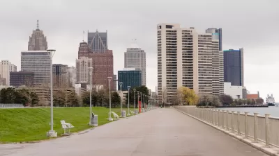
A new framework plan for Detroit's East Riverfront District will focus more on creating public spaces than a previous version of the plan. The proposed vision for the waterfront would expand Milliken State Park and create two new parks.

John Gallagher reports on a new plan for Detroit's east waterfront. "In a bold, new, and more democratic vision unveiled Wednesday evening, city planners showed off a blueprint to create three zones of public parkland on the riverfront where once private development had been scheduled to rise," writes Gallagher.
"The city also plans to create two new Dequindre Cut-style greenways down to the riverfront from the neighborhoods north of Jefferson Avenue to ease public access to the waterfront," adds Gallagher.
The article includes a photo gallery showing images of the current condition at the eastern waterfront, as well as renderings and plan views of the proposed vision for the waterfront.
Louis Aguilar provides additional news coverage of the proposed waterfront plan, along with another set of images. Skidmore Owings and Merrill, which contracted with the Detroit RiverFront Conservancy to generate the plan, also has set up a project page to explain more of the thinking behind the proposes planning vision.
FULL STORY: Detroit's riverfront plan includes a beach, more parks, fewer condos


Community-Driven Designs Proposed for Detroit's West Riverfront Park
Following a plan to line the city's waterfront with redeveloped parkland, Detroit's 22-acre West Riverfront Park will incorporate concepts from a community-led design process.
Shaping a 15-Minute City Vision for Detroit and Cleveland Using Data-Assisted Modeling
How master plans in the two cities hope to transform their historic, and historically underutilized, waterfronts.
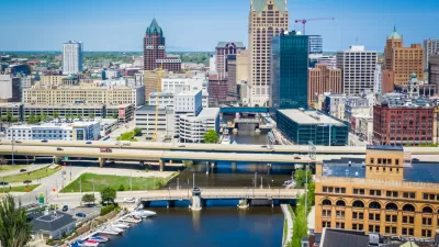
Project Team for Milwaukee's New Downtown Area Plan Takes Shape
A new plan for Milwaukee's downtown will build on a "major renaissance" in the area since the approval of the last version of the plan in 2010.

Planetizen Federal Action Tracker
A weekly monitor of how Trump’s orders and actions are impacting planners and planning in America.

Congressman Proposes Bill to Rename DC Metro “Trump Train”
The Make Autorail Great Again Act would withhold federal funding to the system until the Washington Metropolitan Area Transit Authority (WMATA), rebrands as the Washington Metropolitan Authority for Greater Access (WMAGA).

The Simple Legislative Tool Transforming Vacant Downtowns
In California, Michigan and Georgia, an easy win is bringing dollars — and delight — back to city centers.

The States Losing Rural Delivery Rooms at an Alarming Pace
In some states, as few as 9% of rural hospitals still deliver babies. As a result, rising pre-term births, no adequate pre-term care and "harrowing" close calls are a growing reality.

The Small South Asian Republic Going all in on EVs
Thanks to one simple policy change less than five years ago, 65% of new cars in this Himalayan country are now electric.

DC Backpedals on Bike Lane Protection, Swaps Barriers for Paint
Citing aesthetic concerns, the city is removing the concrete barriers and flexposts that once separated Arizona Avenue cyclists from motor vehicles.
Urban Design for Planners 1: Software Tools
This six-course series explores essential urban design concepts using open source software and equips planners with the tools they need to participate fully in the urban design process.
Planning for Universal Design
Learn the tools for implementing Universal Design in planning regulations.
Smith Gee Studio
City of Charlotte
City of Camden Redevelopment Agency
City of Astoria
Transportation Research & Education Center (TREC) at Portland State University
US High Speed Rail Association
City of Camden Redevelopment Agency
Municipality of Princeton (NJ)