


Montgomery County, Maryland is pursuing significant changes for Downtown Bethesda. The proof is in the draft Bethesda Downtown Plan—a long-range land use plan that would allow a new approach to density.
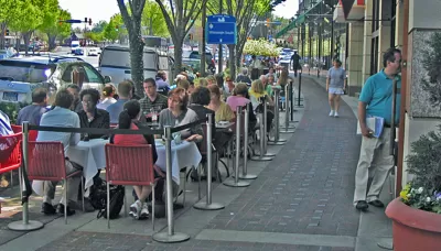
Bill Turque reports on the ongoing Bethesda Downtown Plan underway at the Montgomery County Planning Department. The goal for the new long-range land use plan for Downtown Bethesda: bring the reality of the county's public realm closer to the vision laid out by planners in a 1994 plan.
According to Torque, the current draft plan "places new emphasis on design and environmental sustainability and would require property owners to pay for parks and affordable housing to get permission to build bigger and taller — up to 29 stories along the neighborhood’s central artery."
"The hope is that the downtown Bethesda of 2035 will truly be greener, more walkable and architecturally striking," adds Turque.
Among the innovations proposed by the new plan: pooling the additional density allowed by the new plan, rather than allowing specific levels of density to each project. The plan also proposes a park impact fee, inclusionary zoning, environmental standards, and a design review process.
The Bethesda Downtown Plan is expected for its first hearing with the Montgomery County Council's Planning, Housing and Economic Development Committee in January 2017.
FULL STORY: In downtown Bethesda, residents and county debate whether more height is right

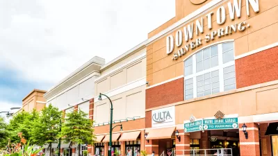
Silver Spring Downtown Plan Expanding to Make Room for the Missing Middle
Planners are hoping that by expanding the boundaries of the Silver Spring Downtown Plan in Montgomery County, Maryland, new opportunities for missing middle housing will create new opportunities for housing affordability.
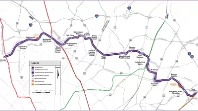
Maryland's Purple Line Clears Final Legal Obstacle
A third lawsuit tried to halt the Purple Line light rail project in Maryland, but it was just the latest lawsuit to get tossed by a judge.
The Days of Two Remaining D.C. Urban Renewal Plans Could Be Numbered
Urban renewal plans for Downtown D.C. and the Shaw neighborhood are all that's left of a mid-20th-century planning effort.

Planetizen Federal Action Tracker
A weekly monitor of how Trump’s orders and actions are impacting planners and planning in America.

Chicago’s Ghost Rails
Just beneath the surface of the modern city lie the remnants of its expansive early 20th-century streetcar system.

San Antonio and Austin are Fusing Into one Massive Megaregion
The region spanning the two central Texas cities is growing fast, posing challenges for local infrastructure and water supplies.

Since Zion's Shuttles Went Electric “The Smog is Gone”
Visitors to Zion National Park can enjoy the canyon via the nation’s first fully electric park shuttle system.

Trump Distributing DOT Safety Funds at 1/10 Rate of Biden
Funds for Safe Streets and other transportation safety and equity programs are being held up by administrative reviews and conflicts with the Trump administration’s priorities.

German Cities Subsidize Taxis for Women Amid Wave of Violence
Free or low-cost taxi rides can help women navigate cities more safely, but critics say the programs don't address the root causes of violence against women.
Urban Design for Planners 1: Software Tools
This six-course series explores essential urban design concepts using open source software and equips planners with the tools they need to participate fully in the urban design process.
Planning for Universal Design
Learn the tools for implementing Universal Design in planning regulations.
planning NEXT
Appalachian Highlands Housing Partners
Mpact (founded as Rail~Volution)
City of Camden Redevelopment Agency
City of Astoria
City of Portland
City of Laramie