


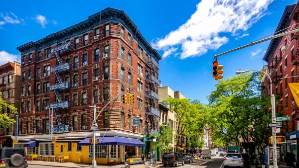
The region surrounding Columbus, Ohio could add a projected one million people by 2050, and developers are looking for new ways to meet growing demand for urban living.

"Columbus developers increasingly are looking up instead of out as they try to build on some of the city’s most desirable streets," report Rick Rouan and Mark Ferenchik.
As available real estate dries up along High Street in the Short North, the University District and Clintonville, developers are asking for zoning exceptions for taller buildings that can handle an expected explosion in the urban population.
While individual development proposals are making more frequent appearances on city council agendas, the city is also considering "raising the maximum allowable height in the University District" to make it easier and less contentious to approve projects.
Naturally, opposition to the development wave has emerged from area commissioners and residents, concerned about neighborhood character and the context of the existing built environment.
FULL STORY: Developers want to build higher along North High Street


Debating the End of Single-Family Zoning in Toronto
A retired city planner takes a position against "lot splitting," or allowing more than one unit on properties zones for single-family residential as it's known in Toronto.

Proposed Density Causes 'Chaos' at the Newark City Council Hearing
A suite of zoning changes that would increase building heights and density along the Passaic River in Newark, New Jersey, provoked a chaotic council hearing that devolved into shouting and the removal of residents from the council chambers.
In Dense NYC, What Does ‘Human Scale’ Mean?
Advocates reject the NIMBY label, arguing that they seek a more sustainable, incremental pace of growth modeled on mid-rise neighborhoods.

Planetizen Federal Action Tracker
A weekly monitor of how Trump’s orders and actions are impacting planners and planning in America.

Congressman Proposes Bill to Rename DC Metro “Trump Train”
The Make Autorail Great Again Act would withhold federal funding to the system until the Washington Metropolitan Area Transit Authority (WMATA), rebrands as the Washington Metropolitan Authority for Greater Access (WMAGA).

The Simple Legislative Tool Transforming Vacant Downtowns
In California, Michigan and Georgia, an easy win is bringing dollars — and delight — back to city centers.

Albuquerque’s Microtransit: A Planner’s Answer to Food Access Gaps
New microtransit vans in Albuquerque aim to close food access gaps by linking low-income areas to grocery stores, cutting travel times by 30 percent and offering planners a scalable model for equity-focused transit.

This City Will Pay You to Meet Your Neighbors
A North Kansas City grant program offers up to $400 for residents to throw neighborhood block parties.

Commentary: Our Silence Will Not Protect Us
Keeping our heads down and our language inoffensive is not the right response to the times we’re in. Solidarity and courage is.
Urban Design for Planners 1: Software Tools
This six-course series explores essential urban design concepts using open source software and equips planners with the tools they need to participate fully in the urban design process.
Planning for Universal Design
Learn the tools for implementing Universal Design in planning regulations.
Smith Gee Studio
City of Charlotte
City of Camden Redevelopment Agency
City of Astoria
Transportation Research & Education Center (TREC) at Portland State University
US High Speed Rail Association
City of Camden Redevelopment Agency
Municipality of Princeton (NJ)