


Comprehensive plans can be big and unwieldy. Luckily for Washington, D.C., there are two maps that unlock of the plan's meaning.
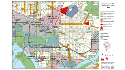
David Whitehead sifts through the 600 pages of the D.C. Comprehensive Plan and identifies the two maps that provide access to the plan's core ideas.
"DC has a giant planning document called the Comprehensive Plan. Most of it is super dense and complicated, but its goal is to lay the foundation for many city-wide decisions, in particular decisions on land use," explains Whitehead. "Partially because of its size and obscurity, many people just focus on two maps that exist as part of the Comp Plan: the Future Land Use Map (FLUM), and the Generalized Policy Map."
Whitehead then digs into both of the two maps, illuminating the key ideas that will help guide an understanding of these already most accessible parts of the D.C. Comprehensive Plan.
But then, there's a caveat. According to Whitehead, "[t]here's one big issue with both of these maps: they tend to preserve the status quo—more specifically, the status quo of 2006, which is when the Comp Plan was created." Luckily, Whitehead reports that the D.C. Office of Planning is "organizing an effort to amend and update the Comprehensive Plan."
FULL STORY: These two maps are the guides to your neighborhood's future. Here's what you should know about them.


D.C. Comprehensive Plan Update Needs Equity Improvements, Report Says
The new D.C. Office of Equity has produced an evaluation of proposed changes to the D.C. Comprehensive Plan.

Comprehensive Plan Update Stokes Controversy in D.C.
Complex political dynamics are mustering for a showdown over D.C.'s comprehensive plan.
Why Have ADUs Proliferated in Portland, Lagged in D.C.?
A new report by the Urban Institute examines the consequences of small differences in land use regulations.

Planetizen Federal Action Tracker
A weekly monitor of how Trump’s orders and actions are impacting planners and planning in America.

San Francisco's School District Spent $105M To Build Affordable Housing for Teachers — And That's Just the Beginning
SFUSD joins a growing list of school districts using their land holdings to address housing affordability challenges faced by their own employees.

The Tiny, Adorable $7,000 Car Turning Japan Onto EVs
The single seat Mibot charges from a regular plug as quickly as an iPad, and is about half the price of an average EV.

Toronto Condo Sales Drop 75%
In two of Canada’s most expensive cities, more condos were built than ever — and sales are plummeting.

Vehicle-related Deaths Drop 29% in Richmond, VA
The seventh year of the city's Vision Zero strategy also cut the number of people killed in alcohol-related crashes by half.

Seattle's Plan for Adopting Driverless Cars
Equity, safety, accessibility and affordability are front of mind as the city prepares for robotaxis and other autonomous vehicles.
Urban Design for Planners 1: Software Tools
This six-course series explores essential urban design concepts using open source software and equips planners with the tools they need to participate fully in the urban design process.
Planning for Universal Design
Learn the tools for implementing Universal Design in planning regulations.
Smith Gee Studio
City of Charlotte
City of Camden Redevelopment Agency
City of Astoria
Transportation Research & Education Center (TREC) at Portland State University
US High Speed Rail Association
City of Camden Redevelopment Agency
Municipality of Princeton (NJ)