


Governors Island in NYC recently reopened after a massive remake into a park that can only be reached by ferry. The park is reviewed by former Empire State Development Corp. VP Carol Berens.
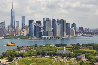
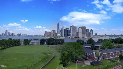
Governors Island recently re-opened to the public after a massive remake into a destination park. Among other things, it contains an historic district with stately old homes and trees, a bicycle trail circling the island, children's play areas, and four man-made hills offering spectacular views of NYC's skylines and bridges. It can only be reached by ferry or private boat but it's less than a ten minute ride. Writes Carol Berens, a former Empire State Development Corp. VP turned author and real estate sales professional:
The plan consists of 87 acres—the Historic District (33 acres) and new park and public spaces (40 acres). The remaining acreage [the island is 172 acres] is slated for commercial development, as yet unannounced.
The $250 million master plan (funded by New York City’s capital plan) was divided into two phases: Phase One, started in 2012 and opened to the public in 2014, added amenities and public spaces such as a food concession plaza, a hedge maze, a 10-acre lawn and play areas including the Hammock Grove, ball fields and relaxation areas as well as new bike paths that snake through the island. The Historic District received signage, lighting and visitor services. Phase Two, called The Hills, not only includes the manipulated landscape, but playground sliding ponds and some site-specific art.
For more about Carol's observations and photos, see source article.
FULL STORY: Day Tripping on Governors Island

The Leadership Behind the Rebirth of Governors Island in New York
Leslie Koch, the president and chief executive of the Trust for Governors Island, in the Hills on Thursday. After leading the trust for a decade, she is announcing her retirement.
Finalists Selected for Governors Island Climate Research Center
Four teams will submit detailed proposals for a new climate research and education center on New York's Governors Island.

Rezoning for Governors Island Approved
A mix of new development focused on future needs and new tools for preservation are included in the rezoning package for the south end of Governors Island approved by the New York City Council in May.

Planetizen Federal Action Tracker
A weekly monitor of how Trump’s orders and actions are impacting planners and planning in America.

Chicago’s Ghost Rails
Just beneath the surface of the modern city lie the remnants of its expansive early 20th-century streetcar system.

San Antonio and Austin are Fusing Into one Massive Megaregion
The region spanning the two central Texas cities is growing fast, posing challenges for local infrastructure and water supplies.

Since Zion's Shuttles Went Electric “The Smog is Gone”
Visitors to Zion National Park can enjoy the canyon via the nation’s first fully electric park shuttle system.

Trump Distributing DOT Safety Funds at 1/10 Rate of Biden
Funds for Safe Streets and other transportation safety and equity programs are being held up by administrative reviews and conflicts with the Trump administration’s priorities.

German Cities Subsidize Taxis for Women Amid Wave of Violence
Free or low-cost taxi rides can help women navigate cities more safely, but critics say the programs don't address the root causes of violence against women.
Urban Design for Planners 1: Software Tools
This six-course series explores essential urban design concepts using open source software and equips planners with the tools they need to participate fully in the urban design process.
Planning for Universal Design
Learn the tools for implementing Universal Design in planning regulations.
planning NEXT
Appalachian Highlands Housing Partners
Mpact (founded as Rail~Volution)
City of Camden Redevelopment Agency
City of Astoria
City of Portland
City of Laramie