


Community input is crucial to a plan that would wrap Portland in a ring of greenery and pathways.
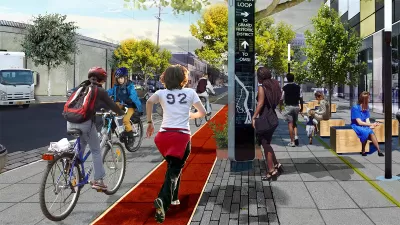
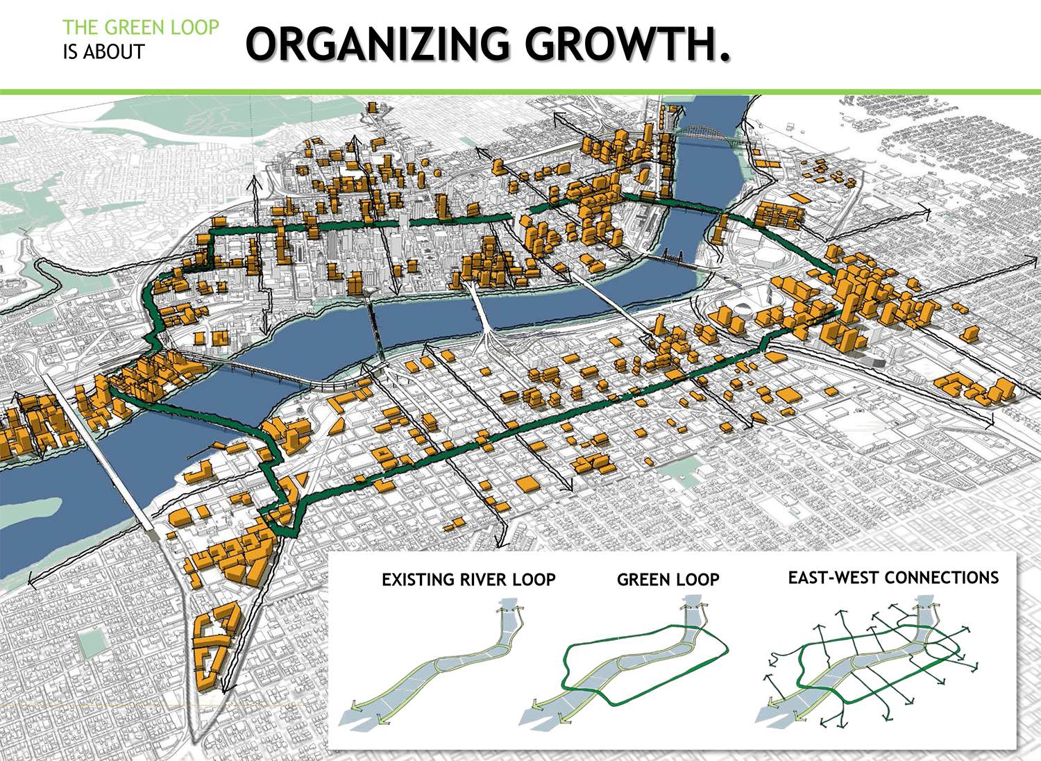
The Green Loop [pdf] is a proposed six-mile network of narrow parks that would link neighborhoods on either side of the Willamette River. Jen Kinney of Next City describes the vision thusly:
At about half the size of a typical Portland city block, the 24 narrow Park Blocks are just what they sound like: corridors of green spaces promenading through the city center. But the north and south segments are disjointed … If linked by a pedestrian and bike path, the Park Blocks would comprise about a mile of the Green Loop; the route would then continue, ultimately encircling the dense neighborhoods on both the east and west sides.
Part of Portland's pending Central City 2035 plan, the proposal is still conceptual. Recently, a pop-up exhibition during an open streets event invited the public to participate in the design process. Untitled Studio, the firm implementing the design, asked visitors to plot potential courses on a map, as well as on a 3D model of a streetscape.
The group is comprised of architects as well as journalists, and Next City details several other comprehensive, interactive community engagement strategies it is developing as part of the design process.
FULL STORY: Portlanders Asked to Imagine Linear Park Design

Study: How Urban Parks Can Support Biodiversity
Conservation and recreation can go hand in hand in urban green spaces designed to serve both humans and local wildlife.

'Greening' L.A.'s Schoolyards
Advocates for increasing green space on school campuses say giving students a more healthy outdoor environment can also reduce the urban heat island effect and improve public health in historically underserved communities.
Magic Johnson Park to Reopen in February
A much-needed park in South Los Angeles will reopen to the public after undergoing major renovations.

Planetizen Federal Action Tracker
A weekly monitor of how Trump’s orders and actions are impacting planners and planning in America.

The Simple Legislative Tool Transforming Vacant Downtowns
In California, Michigan and Georgia, an easy win is bringing dollars — and delight — back to city centers.

San Francisco's School District Spent $105M To Build Affordable Housing for Teachers — And That's Just the Beginning
SFUSD joins a growing list of school districts using their land holdings to address housing affordability challenges faced by their own employees.

In More Metros Than You’d Think, Suburbs are Now More Expensive Than the City
If you're moving to the burbs to save on square footage, data shows you should think again.

The States Losing Rural Delivery Rooms at an Alarming Pace
In some states, as few as 9% of rural hospitals still deliver babies. As a result, rising pre-term births, no adequate pre-term care and "harrowing" close calls are a growing reality.

The Small South Asian Republic Going all in on EVs
Thanks to one simple policy change less than five years ago, 65% of new cars in this Himalayan country are now electric.
Urban Design for Planners 1: Software Tools
This six-course series explores essential urban design concepts using open source software and equips planners with the tools they need to participate fully in the urban design process.
Planning for Universal Design
Learn the tools for implementing Universal Design in planning regulations.
Smith Gee Studio
City of Charlotte
City of Camden Redevelopment Agency
City of Astoria
Transportation Research & Education Center (TREC) at Portland State University
US High Speed Rail Association
City of Camden Redevelopment Agency
Municipality of Princeton (NJ)