


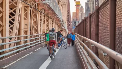
New York City has several famous examples of pedestrian-only environments, but last weekend's Shared Streets event was an experiment in co-existence.
"DOT’s first-ever “Shared Streets” event limited car traffic entering a 60-block section of the Financial District for five hours on Saturday. With the neighborhood free of the near-constant stream of cars passing through on a typical day, pedestrians and cyclists were free to navigate the streets without fear," writes David Meyer.
In choosing the shared streets model instead of closing the streets down entirely to cars, New York's experiment hopefully offered lessons for people on either side of the driving wheel. For those outside of cars, the event offered new access to the streets of Manhattan. The day also (hopefully) showed drivers that they can still get where they're going at a pace safe for all users. The Meyers article also includes a lot of photos of New Yorkers (and a few tourists, presumably) making use of the streets of Manhattan in new ways.
Tom Kutsch also reported on the Shared Streets day in a separate article, noting especially the list of policy outcomes such events are intended to advance—such as improved pedestrian and bike safety and reduced air pollution and carbon emissions.
The city has yet to announce whether the Shared Streets event has a future in New York. Both articles report low turnout due to sweltering heat on the day of the event.
FULL STORY: First-Ever “Shared Streets” Brings Stress-Free Streets to Financial District


Bikes Are More Popular Than Ever in New York City, City Officials Say
Build safe infrastructure and people on bikes will come, according to New York City officials.
New Bike Lanes Planned for Two New York City Bridges
The de Blasio administration is offering a parting gift to the city's cyclists.

New York City Rolling Out First E-Scooters in the Spring
After years of outright banning them, New York City is finally giving e-scooters a chance to operate on its streets.

Maui's Vacation Rental Debate Turns Ugly
Verbal attacks, misinformation campaigns and fistfights plague a high-stakes debate to convert thousands of vacation rentals into long-term housing.

Planetizen Federal Action Tracker
A weekly monitor of how Trump’s orders and actions are impacting planners and planning in America.

San Francisco Suspends Traffic Calming Amidst Record Deaths
Citing “a challenging fiscal landscape,” the city will cease the program on the heels of 42 traffic deaths, including 24 pedestrians.

Bend, Oregon Zoning Reforms Prioritize Small-Scale Housing
The city altered its zoning code to allow multi-family housing and eliminated parking mandates citywide.

Amtrak Cutting Jobs, Funding to High-Speed Rail
The agency plans to cut 10 percent of its workforce and has confirmed it will not fund new high-speed rail projects.

LA Denies Basic Services to Unhoused Residents
The city has repeatedly failed to respond to requests for trash pickup at encampment sites, and eliminated a program that provided mobile showers and toilets.
Urban Design for Planners 1: Software Tools
This six-course series explores essential urban design concepts using open source software and equips planners with the tools they need to participate fully in the urban design process.
Planning for Universal Design
Learn the tools for implementing Universal Design in planning regulations.
planning NEXT
Appalachian Highlands Housing Partners
Mpact (founded as Rail~Volution)
City of Camden Redevelopment Agency
City of Astoria
City of Portland
City of Laramie