


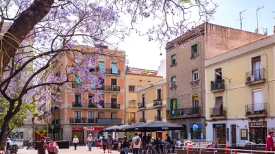
Barcelona wants to be the world’s best city for people. To reclaim the public space and community living that residents lost to cars over the last century, the city is transforming mobility and access to public space by introducing the superblock.
When Catalan urban planner Ildefons Cerdà i Sunyer, back in the 1850s, designed the Eixample, the expansion of Barcelona outside the old city walls, he envisioned a city based on community living, where people could interact on wide streets, with a wealth of public and private gardens, and where transportation of people and goods wouldn’t dominate public space.
What Cerdà could not foresee in his plan, approved by the city on 1859, was the arrival of the automobile and the resulting transformation of mobility that took place in the middle of the 20th century.
The Barcelona government, however, has a new plan, which aims to reclaim most of the streets for the community, without reducing traffic flow. The plan is modeled on the original idea of the Eixample, and expands the area into “Super Illes”, the Catalan term for Superblocks.
FULL STORY: Superblocks, Barcelona Answer to Car-Centric City

Could Los Angeles Emulate Barcelona’s ‘Superblocks’?
A proposal in the city council could bring the ‘superblock’ model to Los Angeles, opening up neighborhood streets to more biking, walking, and public amenities.
Barcelona's Long-Term, Pedestrian-First Plan Continues with the 'Barcelona Superblock'
Mayor Ada Colau announced the next step in Barcelona's plan to convert the city center into a "new city for the present and the future."
What Would Cities Look Like if They Were Designed by Women?
Cities are built by men, and so too often urban design does not reflect the needs, perspectives, and realities of women.

Montreal Mall to Become 6,000 Housing Units
Place Versailles will be transformed into a mixed-use complex over the next 25 years.

Planetizen Federal Action Tracker
A weekly monitor of how Trump’s orders and actions are impacting planners and planning in America.

DARTSpace Platform Streamlines Dallas TOD Application Process
The Dallas transit agency hopes a shorter permitting timeline will boost transit-oriented development around rail stations.

Without International Immigrants, the Rural US Population Would Be Falling 58%
Census data shows that population growth in rural areas is due in large part to international migrants.

Dead End: Nine Highways Ready for Retirement
The Freeways Without Futures report describes the nation’s most promising highway removal proposals.

Congressman Proposes Bill to Rename DC Metro “Trump Train”
The Make Autorail Great Again Act would withhold federal funding to the system until the Washington Metropolitan Area Transit Authority (WMATA), rebrands as the Washington Metropolitan Authority for Greater Access (WMAGA).
Urban Design for Planners 1: Software Tools
This six-course series explores essential urban design concepts using open source software and equips planners with the tools they need to participate fully in the urban design process.
Planning for Universal Design
Learn the tools for implementing Universal Design in planning regulations.
City of Mt Shasta
City of Camden Redevelopment Agency
City of Astoria
Transportation Research & Education Center (TREC) at Portland State University
City of Camden Redevelopment Agency
Municipality of Princeton (NJ)
Regional Transportation Commission of Southern Nevada