


The findings of a report on changes occurring in Philadelphia Center City finds more residents and workers walking, biking, and taking transit. (Thankfully, they aren't all looking for parking every day.)
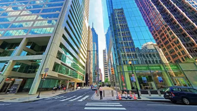
An article by Jim Saksa begins with a question: "If everyone drove to work in Center City, how much parking would we need?"
The answer is included in a new report from Center City District: "2.6 square miles of surface parking. The size of William Penn’s 1682 plan for the city? 2.2 miles." Another way of quantifying that scale of parking need: it also equals 28 Comcast-Center-Side parking garages.
That's the big ticket item is a collection of findings reported in the most recent edition of Center City Reports. Saksa calls on the expertise of Center City District Executive Director Paul Levy to explain the findings of the report. Center City, like many other downtowns around the country, is growing—both in terms of jobs and residents.
Apropos of that initial anecdote about parking: parking spaces have decreased while available parking has increased. Clearly more of the new residents and workers in Center City are choosing other modes of transportation besides the car.
FULL STORY: Center City District report highlights transit as competitive necessity for region’s economy

Parking Spaces Reduced in Center City Philadelphia—Along With Parking Occupancy
Philadelphia is providing a living case study of the tenants of the Donald Shoup-approach to parking.

A Coming of Age Story for Philadelphia's Revitalized Center City
A housing report by analyzing Philadelphia's Center City enunciates an obstacle facing many cities in the throes of downtown revitalization: What happens when Millennials don't come home to roost?
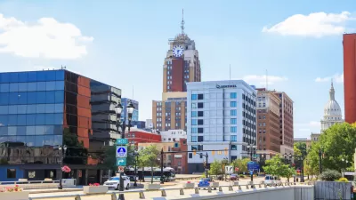
East Lansing Parking Plan Aims for Walkability
East Lansing wants to ditch some of its surface parking to encourage economic activity and walkability.

Montreal Mall to Become 6,000 Housing Units
Place Versailles will be transformed into a mixed-use complex over the next 25 years.

Planetizen Federal Action Tracker
A weekly monitor of how Trump’s orders and actions are impacting planners and planning in America.

DARTSpace Platform Streamlines Dallas TOD Application Process
The Dallas transit agency hopes a shorter permitting timeline will boost transit-oriented development around rail stations.

Interactive Map Reveals America's “Shade Deserts”
Launched by UCLA and American Forests to combat heat-related deaths, the tool maps the shade infrastructure for over 360 U.S. cities.

Bicycles and Books — In Sacramento, Libraries Now Offer Both
Adult library card holders can check out e-bikes and e-trikes for up to one week.

Colorado Landfills Emit as Much Pollution as 1M Cars
Landfills are the third-largest source of methane pollution in Colorado, after agriculture and fossil fuel extraction.
Urban Design for Planners 1: Software Tools
This six-course series explores essential urban design concepts using open source software and equips planners with the tools they need to participate fully in the urban design process.
Planning for Universal Design
Learn the tools for implementing Universal Design in planning regulations.
City of Mt Shasta
City of Camden Redevelopment Agency
City of Astoria
Transportation Research & Education Center (TREC) at Portland State University
US High Speed Rail Association
City of Camden Redevelopment Agency
Municipality of Princeton (NJ)