Decades of poor urban planning and policy decisions have contributed to "the Glasgow Effect," which has seen higher rates of mortality for Glaswegians compared to similar de-industrialized cities.


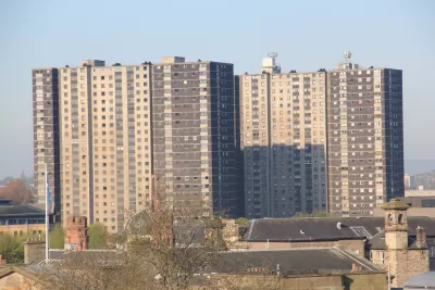
Researchers have tied the high rates of mortality for Glaswegians under the age of 65 to decades of poor planning and policy decisions, reports Karin Goodwin of The Guardian. "The Glasgow Effect," as labelled by researchers, has seen a 30 percent higher risk of dying below the age of 65 from the typical causes of cancer and heart disease, as well as the despair diseases of alcoholism and suicide.
The cause of the higher rate of mortality among residents of Glasgow has roots in the policy and planning decisions from the '60s, '70s, and '80s that shifted portions of the population—primarily younger workers and their families—to new towns on the outskirts of the city leaving the poor and elderly in Glasgow's center in high rise housing and peripheral estates.
The schemes of modern Glasgow are often desolate and surrounded by vacant land: 91% of people in Springburn (pdf)– in the north of the city – live 500 metres from vacant or derelict land; Maryhill – in the west – it’s 85%; and in Shettleston – the east – 74%.
This could be having serious effects; earlier this year a statistical analysis of Glasgow (pdf) by Juliana Maantay and Andrew Maroko of City University of New York (CUNY), found a link between poor mental health and the proximity to vacant or derelict link. They also found the effect was lessened when communities had a role in the urban planning process.
Goodwin reports that the tide may be turning in terms of political will to fix the planning mistakes of the past, thanks to new leadership from the Scottish National Party (SNP). However, challenges remain to actually fund the change required to turn around Glasgow's high mortality rate.
Read the full story: The Glasgow effect: 'We die young here - but you just get on with it'
California Halts Three Years of Population Loss
The Golden State grew by 67,000 people, or 0.17%, last year, to just over 39.1 million on Jan. 1, 2024, according to a demographic report released April 30 by the California Department of Finance.
How Urban Trees Save Lives
New research shows a strong connection between a healthy urban tree canopy and lowered mortality rates.
Key Lessons From COP26
Observers express cautious optimism as countries come together on climate goals, but developing nations say they need more support to mitigate the impacts of climate change already in progress.

Planetizen Federal Action Tracker
A weekly monitor of how Trump’s orders and actions are impacting planners and planning in America.

California plans to bury El Niño’s downpour
If the state plays its cards right, it may be able to store a billion acre-feet of El Niño’s water in aquifers.

Desperate measures: Advocates weigh draining Lake Powell to fill Colorado River
Draining the reservoir could reduce evaporation losses by a couple hundred thousand acre-feet.

US buildings threatened, destroyed by fires set to triple by 2060
Researchers found a high fire risk for socioeconomically vulnerable neighborhoods in the American West.

LA residents may be allowed to paint their own crosswalks
Councilwoman Katy Yaroslavsky put out a motion instructing the Los Angeles Department of Public Transportation to study the feasibility of allowing volunteers to paint crosswalks.

Dallas moves to overhaul its zoning code
The city's zoning reform will allow more multi-family and mixed-use developments.

FREE Course: Walkable City 1: Why Walkability?
After describing his path towards focusing on walkability as the essence of good planning, Jeff Speck marches through his five principal reasons for making more walkable places.
Reinventing Malls: Planning Alchemy—Turning Gray Fields Into Gold
The course focuses on the opportunities and imperatives that shape reinvention of mall sites.

City of Rosemead
Rutgers University, Edward J. Bloustein School of Planning and Public Policy
One Hundred Miles
Hunter College, City University of New York (CUNY)
The Architects Foundation
University of Cincinnati Online
City of Cambridge
Montrose County
The Pocatello Development Authority