


340 acres of vacant property, granted by the Federal Aviation Authority in the 1970s and 1980s, has a new vision for the future.
The Los Angeles City Council this week approved the LAX Northside Plan Update, "a comprehensive planning blueprint for 340 acres of vacant property located between Los Angeles International Airport (LAX) and the Los Angeles communities of Westchester and Playa del Rey."
The LAX Northside Plan Update was in the works for several years, according to a press release announcing the approval from Councilmember Mike Bonin, who represents the area. :"The plan represents a unique opportunity to achieve significant economic investment in the area and provide needed community resources and benefits, as well as important airport support sites."
After listing the standard soundbites from Councilmember Bonin, Mayor Eric Garcetti, and airport officials, the press release also included a history of the property and details of the community outreach process. Among the details of the new plan is a significant reduction in allowable density, according to the press release, from the old LAX Northside Plan drafted in the 1980s.
FULL STORY: LAX Northside Plan Approved

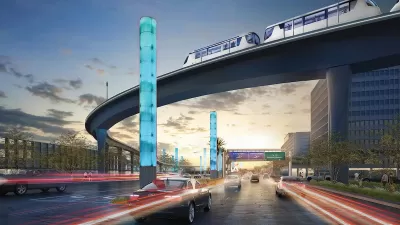
LA City Council Approves Extra Funding for LAX People Mover
The automated electric rail system is expected to carry up to 30 million passengers per year to points in and around the Los Angeles International Airport.
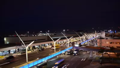
Congestion Tipping Point: Uber and Lyft Banned from LAX
Automobile traffic to LAX has increased by half in the last decade, and congestion has passed a tipping point.

Los Angeles Investing in a Transit-Oriented Olympics
Ahead of the 2028 Olympic Games, Los Angeles is rallying around infrastructure buildout and technological advancement.

Planetizen Federal Action Tracker
A weekly monitor of how Trump’s orders and actions are impacting planners and planning in America.

San Francisco's School District Spent $105M To Build Affordable Housing for Teachers — And That's Just the Beginning
SFUSD joins a growing list of school districts using their land holdings to address housing affordability challenges faced by their own employees.

Can We Please Give Communities the Design They Deserve?
Often an afterthought, graphic design impacts everything from how we navigate a city to how we feel about it. One designer argues: the people deserve better.

The EV “Charging Divide” Plaguing Rural America
With “the deck stacked” against rural areas, will the great electric American road trip ever be a reality?

Judge Halts Brooklyn Bike Lane Removal
Lawyers must prove the city was not acting “arbitrarily, capriciously, and illegally” in ordering the hasty removal.

Engineers Gave America's Roads an Almost Failing Grade — Why Aren't We Fixing Them?
With over a trillion dollars spent on roads that are still falling apart, advocates propose a new “fix it first” framework.
Urban Design for Planners 1: Software Tools
This six-course series explores essential urban design concepts using open source software and equips planners with the tools they need to participate fully in the urban design process.
Planning for Universal Design
Learn the tools for implementing Universal Design in planning regulations.
Borough of Carlisle
Smith Gee Studio
City of Camden Redevelopment Agency
City of Astoria
Transportation Research & Education Center (TREC) at Portland State University
City of Camden Redevelopment Agency
Municipality of Princeton (NJ)