


The Texas Department of Transportation (TxDOT) has envisioned a future for Downtown Dallas that includes more downtown and fewer freeways.
Brandon Formby reports on a "surprising yet powerful voice" adding to the "joining the chorus calling for a sea change in downtown Dallas’ car-centric infrastructure building":
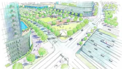
The Texas Department of Transportation released a report Friday [June 10] that lays out several scenarios for minimizing congestion on the noose of aging highways that chokes off urban neighborhoods from the Central Business District. The study, called CityMAP, offers a stark departure from the agency’s standby approach of adding more highway lanes or re-engineering traffic chokepoints.
Included among the options explored in the CityMAP (short for the Dallas City Center Master Assessment Process) report: tearing down Interstate 345 and moving a stretch of Interstate 30 out of downtown to a new route farther south in Fair Park.
According to Formby, "CityMAP doesn’t suggest one construction option over another. Instead, the report is meant to arm urbanites, city officials and regional planners with data and estimated effects so a holistic plan can be pieced together for the urban core’s transportation network."
FULL STORY: New TxDOT downtown Dallas plan includes a scenario with a freeway's demise

Dallas City Hall Begins to Ponder a New Future for the I-345
A proposal once too controversial to consider is gaining traction at several layers of government.

Columnist to Dallas: Tear Down That Freeway
Freeways have been removed before, but if the Texas Department of Transportation decides to tear down the I-345 freeway in Dallas, it would reflect a massive sea change in urban transportation planning.
The Right Planning Consultant Could Make All of the Difference
Between DART service optimization and deciding the fate of I-345, Dallas has big of decisions to make. The right consultant, who understands accurate framing of planning issues, could help choose a route that best serves Dallasites.

Maui's Vacation Rental Debate Turns Ugly
Verbal attacks, misinformation campaigns and fistfights plague a high-stakes debate to convert thousands of vacation rentals into long-term housing.

Planetizen Federal Action Tracker
A weekly monitor of how Trump’s orders and actions are impacting planners and planning in America.

In Urban Planning, AI Prompting Could be the New Design Thinking
Creativity has long been key to great urban design. What if we see AI as our new creative partner?

King County Supportive Housing Program Offers Hope for Unhoused Residents
The county is taking a ‘Housing First’ approach that prioritizes getting people into housing, then offering wraparound supportive services.

Researchers Use AI to Get Clearer Picture of US Housing
Analysts are using artificial intelligence to supercharge their research by allowing them to comb through data faster. Though these AI tools can be error prone, they save time and housing researchers are optimistic about the future.

Making Shared Micromobility More Inclusive
Cities and shared mobility system operators can do more to include people with disabilities in planning and operations, per a new report.
Urban Design for Planners 1: Software Tools
This six-course series explores essential urban design concepts using open source software and equips planners with the tools they need to participate fully in the urban design process.
Planning for Universal Design
Learn the tools for implementing Universal Design in planning regulations.
planning NEXT
Appalachian Highlands Housing Partners
Mpact (founded as Rail~Volution)
City of Camden Redevelopment Agency
City of Astoria
City of Portland
City of Laramie