


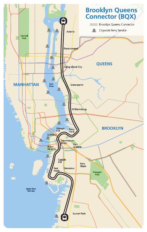
Mayor Bill de Blasio is expected to announce ambitious plans for a 16-mile, $2.2 billion streetcar route to connect some of the city's up and coming, but still transit-light, neighborhoods.
"In a major reimagining of the New York City waterfront, Mayor Bill de Blasio is set to propose a streetcar line that would snake along the East River in Brooklyn and Queens, linking the industrial centers of Sunset Park to the upper reaches of Astoria," reports Michael M. Grynbaum.
Mayor de Blasio's streetcar plan calls for a 16-mile rail line, "that runs on rails embedded in public roadways and flows alongside automobile traffic," according to Grynbaum.
The expected cost of the system is $2.2 billion, and "[a]dministration officials believe the cost can be offset by a revenue stream taken from the expected rise in property values along the route." As Grynbaum notes, the neighborhoods along the route, like Greenpoint and Brooklyn Navy Yard, have already undergone rapid development.
The article also credits the proposal to the "long-held fantasy of the city's urban planners…" The proposed map for the so-called Brooklyn Queens Connector can be seen below.
FULL STORY: Mayor de Blasio to Propose Streetcar Line Linking Brooklyn and Queens


Brooklyn-Queens Connector Streetcar Plans Released
Plans for the Brooklyn-Queens Connector, otherwise known as the BQX, are still on the table, despite reports of the project's demise.

MIA or DOA? The Brooklyn-Queens Streetcar Fading Fast
The lack of news on the proposed Brooklyn Queens Connector (BQX) is hardly a death knell, but that doesn't mean no news is good news, either.

Op-Ed: Brooklyn-to-Queens Streetcar Won't Pay for Itself
Who thinks the Brooklyn-to-Queens (BQX) would pay for itself? Someone whose paycheck depends on it, Neil deMause argues.

Planetizen Federal Action Tracker
A weekly monitor of how Trump’s orders and actions are impacting planners and planning in America.

Chicago’s Ghost Rails
Just beneath the surface of the modern city lie the remnants of its expansive early 20th-century streetcar system.

Amtrak Cutting Jobs, Funding to High-Speed Rail
The agency plans to cut 10 percent of its workforce and has confirmed it will not fund new high-speed rail projects.

Ohio Forces Data Centers to Prepay for Power
Utilities are calling on states to hold data center operators responsible for new energy demands to prevent leaving consumers on the hook for their bills.

MARTA CEO Steps Down Amid Citizenship Concerns
MARTA’s board announced Thursday that its chief, who is from Canada, is resigning due to questions about his immigration status.

Silicon Valley ‘Bike Superhighway’ Awarded $14M State Grant
A Caltrans grant brings the 10-mile Central Bikeway project connecting Santa Clara and East San Jose closer to fruition.
Urban Design for Planners 1: Software Tools
This six-course series explores essential urban design concepts using open source software and equips planners with the tools they need to participate fully in the urban design process.
Planning for Universal Design
Learn the tools for implementing Universal Design in planning regulations.
Caltrans
City of Fort Worth
Mpact (founded as Rail~Volution)
City of Camden Redevelopment Agency
City of Astoria
City of Portland
City of Laramie