


It makes sense that the transit agency serving the Silicon Valley would be one of the first to adopt a formal open data policy.
The Santa Clara Valley Transit Authority (VTA) announced the formal adoption of an open data policy earlier this month, according to an post by Cody Kraatz.
The announcement "makes VTA the first government organization in Santa Clara County, one of the first agencies in the Bay Area, and perhaps the first transit operator in the country to adopt a formal Open Data Policy," according to Kraatz.
The Open Data policy is the work of the VTA's Transportation Innovation Center. "The policy creates a standard for proactively releasing VTA’s valuable transportation data through our Open Data Portal at data.vta.org. All data released through the portal will be 'machine readable,' meaning it will use formats that software can understand and manipulate rather than PDFs or text documents only people can read," reports Kraatz.
The article also includes some description of the potential of open data to improve public engagement and as a tool for economic development.
FULL STORY: VTA Adopts Open Data Policy, Sets the Default to Open

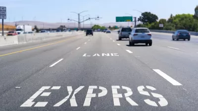
Congestion Pricing in the San Francisco Bay Area
Planners call them “express lanes,” but make no mistake, they are congestion pricing in action, and they're successful. The Bay Area network of what the Federal Highway Administration calls “high-occupancy toll (HOT) lanes” is growing.

Washington DC Launches Open Data Chatbot
City data is now available literally at the public’s fingertips, no data analytics skills required.

BART’s Phase II Extension Into San Jose Ready to Go
A long-awaited extension of the Bay Area’s regional rail transit system is finally coming into view, with an expected completion date of 2030.

Maui's Vacation Rental Debate Turns Ugly
Verbal attacks, misinformation campaigns and fistfights plague a high-stakes debate to convert thousands of vacation rentals into long-term housing.

Planetizen Federal Action Tracker
A weekly monitor of how Trump’s orders and actions are impacting planners and planning in America.

Chicago’s Ghost Rails
Just beneath the surface of the modern city lie the remnants of its expansive early 20th-century streetcar system.

Bend, Oregon Zoning Reforms Prioritize Small-Scale Housing
The city altered its zoning code to allow multi-family housing and eliminated parking mandates citywide.

Amtrak Cutting Jobs, Funding to High-Speed Rail
The agency plans to cut 10 percent of its workforce and has confirmed it will not fund new high-speed rail projects.

LA Denies Basic Services to Unhoused Residents
The city has repeatedly failed to respond to requests for trash pickup at encampment sites, and eliminated a program that provided mobile showers and toilets.
Urban Design for Planners 1: Software Tools
This six-course series explores essential urban design concepts using open source software and equips planners with the tools they need to participate fully in the urban design process.
Planning for Universal Design
Learn the tools for implementing Universal Design in planning regulations.
planning NEXT
Appalachian Highlands Housing Partners
Mpact (founded as Rail~Volution)
City of Camden Redevelopment Agency
City of Astoria
City of Portland
City of Laramie