


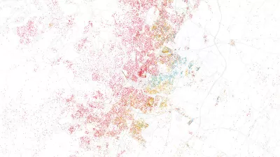
Geographer Duncan Smith mapped the predicted trajectory of worldwide urban growth from 1950 through 2030. Concentric circles of different shades show where and when growth was (or will be) the most dramatic.

CityLab writer Tanvi Misra has high praise for an interactive map of worldwide urban growth created by urban geographer Duncan Smith.
Misra writes, "In its 2014 World Urbanization Prospects report, the UN tracked the populations of major cities from 1950 to 2014, then predicted how these populations would grow (or shrink) up to the year 2030. Using these data, Smith represented each city on his map with a dark blue core, the size of which is proportional to the city's 1950 population. The concentric circles around that core, in lighter blue, vary according to the city's population in 1990, 2015, and 2030."
The result, which is quite pretty to look at, also highlights urbanization's dramatic shift from West to East. Urban China and India, as well as several African cities, stand out as new powerhouses come 2030.
FULL STORY: Mapping 65 Years of Explosive Urban Growth


As Temperatures Increase, Maps Show Sea-Level Rise Will Devastate Cities
Data visualizations illustrate the catastrophic consequences of single-digit global temperature increases.
Visualizing the Growth of the World's Urban Population
An interactive visualization recently released by Unicef presents a startling picture of the world's urban population growth from 1950 to 2050. Mark Wilson deconstructs its implications.
Esri App Makes Data Visualization Easy
A wealth of pre-authored policy maps lets users access data to explore public policy issues.

Maui's Vacation Rental Debate Turns Ugly
Verbal attacks, misinformation campaigns and fistfights plague a high-stakes debate to convert thousands of vacation rentals into long-term housing.

Planetizen Federal Action Tracker
A weekly monitor of how Trump’s orders and actions are impacting planners and planning in America.

San Francisco Suspends Traffic Calming Amidst Record Deaths
Citing “a challenging fiscal landscape,” the city will cease the program on the heels of 42 traffic deaths, including 24 pedestrians.

Defunct Pittsburgh Power Plant to Become Residential Tower
A decommissioned steam heat plant will be redeveloped into almost 100 affordable housing units.

Trump Prompts Restructuring of Transportation Research Board in “Unprecedented Overreach”
The TRB has eliminated more than half of its committees including those focused on climate, equity, and cities.

Amtrak Rolls Out New Orleans to Alabama “Mardi Gras” Train
The new service will operate morning and evening departures between Mobile and New Orleans.
Urban Design for Planners 1: Software Tools
This six-course series explores essential urban design concepts using open source software and equips planners with the tools they need to participate fully in the urban design process.
Planning for Universal Design
Learn the tools for implementing Universal Design in planning regulations.
Heyer Gruel & Associates PA
JM Goldson LLC
Custer County Colorado
City of Camden Redevelopment Agency
City of Astoria
Transportation Research & Education Center (TREC) at Portland State University
Jefferson Parish Government
Camden Redevelopment Agency
City of Claremont